Bowen geodata
Bowen (Queensland) is a seat of a second-order administrative division; located in Australia in Australia/Brisbane (GMT+10) time zone. With population of 11,417 people, there are 469 cities with bigger population in this country. Compared to other cities in Australia, 94.6% of cities are located further ↓South; 51.4% of cities are located further ←West and 88.3% of cities have higher elevation than Bowen. Note1


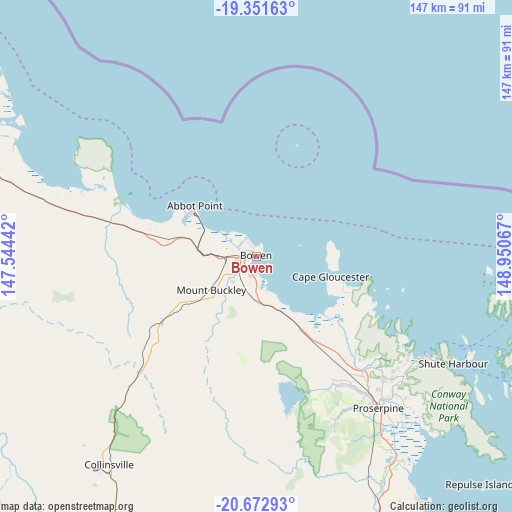
Bowen GPS coordinates[2]
20° 0' 49.212" South, 148° 14' 51.144" East
| Map corner | latitude | longitude |
|---|---|---|
| Upper-left | -19.35163°, | 147.54442° |
| Center: | -20.01367°, | 148.24754° |
| Lower-right: | -20.67293°, | 148.95067° |
| Map W x H: | 146.9×146.9 km | = 91.3×91.3mi |
| max Lat: | -10.58257° ⇑5.4% North |
| Bowen: | -20.01367° |
| min Lat: | ⇓94.6% South -43.31423° |
| min Long | Bowen | max Long |
| 113.53327° | 148.24754° | 153.61246° |
| W 51.4%⇐ | ⇒48.6% E |
Elevation
Elevation of Bowen is 10 m = 33 ft, and this is 112 m = 367 ft below average elevation for this country.
| Max E: |
1715 m = 5627 ft | 88.3% |
| Avg. | 122 m = 400 ft | |
| Bowen | 10 m = 33 ft | |
Min E: |
-2 m = -7 ft | 11.7% |
See also: Australia elevation on elevation.city.
Geographical zone
Bowen is located in South Torrid zone (between Equator and Tropic of Capricorn). Distance of this Southern Tropic circle is 380.6 km =236.5 mi to South.| Distance of | km | miles | from Bowen |
|---|---|---|---|
| Equator | 2225.3 | 1382.7 | to North |
| Tropic Capricorn | 380.6 | 236.5 | to South |
| Antarctic Circle | 5175.9 | 3216.2 | to South |
| South Pole | 7781.8 | 4835.4 | to South |


Nearby cities:
15 places around Bowen: (largest is in red/bold)
• Airlie Beach
56.3 km =35 mi,  120°
120°
• Ayr
100.6 km =62.5 mi,  299°
299°
• Bloomsbury
86.4 km =53.7 mi,  154°
154°
• Brandon
106.6 km =66.2 mi, 298°
• Cannon Valley
54.1 km =33.6 mi,  128°
128°
• Cannonvale
55.3 km =34.4 mi, 121°
• Collinsville
73.2 km =45.5 mi,  215°
215°
• Finch Hatton
131.4 km =81.6 mi,  162°
162°
• Home Hill
95.8 km =59.5 mi,  294°
294°
• Jubilee Pocket
58.8 km =36.5 mi, 121°
• Proserpine
55.3 km =34.4 mi,  141°
141°
• Red Hill
42.8 km =26.6 mi, 141°
• Seaforth
123.9 km =77 mi, 142°
• Strathdickie
52.4 km =32.6 mi, 132°
• Whitsundays
70.5 km =43.8 mi,  99°
99°
Sources, notices
• [Note1] Compared only with cities in Australia existing in our database
• [Src1] Map data: © OpenStreetMap contributors (CC-BY-SA)
• [Src2] Other city data from geonames.org with taken over terms of usage.
• [Src3] Geographical zone / Annual Mean Temperature by Robert A. Rohde @ Wikipedia
