Whitsundays geodata
Whitsundays (Queensland) is a section of populated place; located in Australia in Australia/Brisbane (GMT+10) time zone. With population of 4,481 people, there are 1632 cities with bigger population in this country. Compared to other cities in Australia, 94.4% of cities are located further ↓South; 52.5% of cities are located further ←West and 61.1% of cities have higher elevation than Whitsundays. Note1


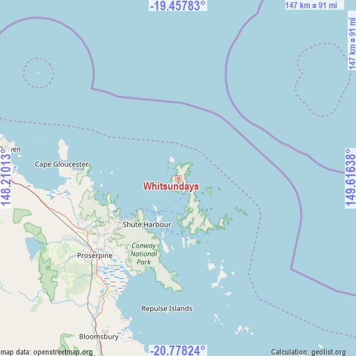
Whitsundays GPS coordinates[2]
20° 7' 9.948" South, 148° 54' 47.7" East
| Map corner | latitude | longitude |
|---|---|---|
| Upper-left | -19.45783°, | 148.21013° |
| Center: | -20.11943°, | 148.91325° |
| Lower-right: | -20.77824°, | 149.61638° |
| Map W x H: | 146.8×146.8 km | = 91.2×91.2mi |
| max Lat: | -10.58257° ⇑5.6% North |
| Whitsundays: | -20.11943° |
| min Lat: | ⇓94.4% South -43.31423° |
| min Long | Whitsundays | max Long |
| 113.53327° | 148.91325° | 153.61246° |
| W 52.5%⇐ | ⇒47.5% E |
Elevation
Elevation of Whitsundays is 31 m = 102 ft, and this is 91 m = 299 ft below average elevation for this country.
| Max E: |
1715 m = 5627 ft | 61.1% |
| Avg. | 122 m = 400 ft | |
| Whitsundays | 31 m = 102 ft | |
Min E: |
-2 m = -7 ft | 38.9% |
See also: Australia elevation on elevation.city.
Geographical zone
Whitsundays is located in South Torrid zone (between Equator and Tropic of Capricorn). Distance of this Southern Tropic circle is 368.8 km =229.2 mi to South.| Distance of | km | miles | from Whitsundays |
|---|---|---|---|
| Equator | 2237.1 | 1390.1 | to North |
| Tropic Capricorn | 368.8 | 229.2 | to South |
| Antarctic Circle | 5164.1 | 3208.8 | to South |
| South Pole | 7770 | 4828.1 | to South |


Nearby cities:
15 places around Whitsundays: (largest is in red/bold)
• Airlie Beach
26.5 km =16.5 mi,  231°
231°
• Bloomsbury
74 km =46 mi,  206°
206°
• Bowen
70.5 km =43.8 mi,  279°
279°
• Bucasia
104.9 km =65.2 mi,  165°
165°
• Cannon Valley
35 km =21.7 mi, 231°
• Cannonvale
28.5 km =17.7 mi, 232°
• Habana
103.1 km =64.1 mi, 170°
• Hampden
105.3 km =65.4 mi,  178°
178°
• Jubilee Pocket
26.8 km =16.7 mi, 225°
• Kuttabul
101.6 km =63.1 mi, 180°
• Proserpine
46.8 km =29.1 mi, 227°
• Red Hill
48.4 km =30.1 mi,  243°
243°
• Seaforth
87 km =54.1 mi, 176°
• Shoal Point
101.5 km =63.1 mi, 165°
• Strathdickie
39 km =24.2 mi, 232°
Sources, notices
• [Note1] Compared only with cities in Australia existing in our database
• [Src1] Map data: © OpenStreetMap contributors (CC-BY-SA)
• [Src2] Other city data from geonames.org with taken over terms of usage.
• [Src3] Geographical zone / Annual Mean Temperature by Robert A. Rohde @ Wikipedia
