Cootamundra geodata
Cootamundra (New South Wales) is a populated place; located in Australia in Australia/Sydney (GMT+11) time zone. With population of 6,618 people, there are 1044 cities with bigger population in this country. Compared to other cities in Australia, 64.4% of cities are located further ↑North; 51% of cities are located further ←West and 88.7% of cities have lower elevation than Cootamundra. Note1


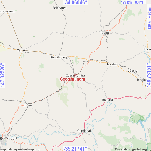
Cootamundra GPS coordinates[2]
34° 38' 27.42" South, 148° 1' 42.168" East
| Map corner | latitude | longitude |
|---|---|---|
| Upper-left | -34.06046°, | 147.32526° |
| Center: | -34.64095°, | 148.02838° |
| Lower-right: | -35.21741°, | 148.73151° |
| Map W x H: | 128.6×128.6 km | = 79.9×79.9mi |
| max Lat: | -10.58257° ⇑64.4% North |
| Cootamundra: | -34.64095° |
| min Lat: | ⇓35.6% South -43.31423° |
| min Long | Cootamundra | max Long |
| 113.53327° | 148.02838° | 153.61246° |
| W 51%⇐ | ⇒49% E |
Elevation
Elevation of Cootamundra is 332 m = 1089 ft, and this is 210 m = 689 ft above average elevation for this country.
| Max E: |
1715 m = 5627 ft | 11.3% |
| Cootamundra | 332 m 1089 ft | |
| Avg. | 122 m = 400 ft | |
Min E: |
-2 m = -7 ft | 88.7% |
See also: Australia elevation on elevation.city.
Geographical zone
Cootamundra is located in South temperate zone (between Tropic of Capricorn and the Antarctic Circle). Distance of this Southern Tropic circle is 1245.8 km =774.1 mi to North.| Distance of | km | miles | from Cootamundra |
|---|---|---|---|
| Equator | 3851.7 | 2393.3 | to North |
| Tropic Capricorn | 1245.8 | 774.1 | to North |
| Antarctic Circle | 3549.5 | 2205.6 | to South |
| South Pole | 6155.3 | 3824.7 | to South |


Nearby cities:
15 places around Cootamundra: (largest is in red/bold)
• Adelong
73.9 km =45.9 mi,  177°
177°
• Binalong
55.6 km =34.5 mi,  93°
93°
• Boorooma
77.4 km =48.1 mi,  231°
231°
• Boorowa
67 km =41.6 mi,  70°
70°
• Bowning
72.3 km =44.9 mi,  99°
99°
• Charles Sturt University
77.2 km =48 mi, 232°
• Coolamon
78.5 km =48.8 mi,  255°
255°
• Estella
77.8 km =48.3 mi, 231°
• Forest Hill
76.2 km =47.3 mi,  222°
222°
• Gundagai
47.5 km =29.5 mi,  171°
171°
• Junee
47.9 km =29.8 mi,  238°
238°
• South Gundagai
49.4 km =30.7 mi, 172°
• Temora
50 km =31.1 mi,  295°
295°
• Tumut
76 km =47.2 mi, 166°
• Young
44.2 km =27.5 mi,  34°
34°
Sources, notices
• [Note1] Compared only with cities in Australia existing in our database
• [Src1] Map data: © OpenStreetMap contributors (CC-BY-SA)
• [Src2] Other city data from geonames.org with taken over terms of usage.
• [Src3] Geographical zone / Annual Mean Temperature by Robert A. Rohde @ Wikipedia
