Cowes geodata
Cowes (Victoria) is a populated place; located in Australia in Australia/Melbourne (GMT+11) time zone. With population of 4,770 people, there are 1545 cities with bigger population in this country. Compared to other cities in Australia, 95.8% of cities are located further ↑North; 62.2% of cities are located further →East and 63.7% of cities have higher elevation than Cowes. Note1


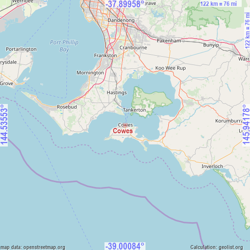
Cowes GPS coordinates[2]
38° 27' 8.316" South, 145° 14' 19.14" East
| Map corner | latitude | longitude |
|---|---|---|
| Upper-left | -37.89958°, | 144.53553° |
| Center: | -38.45231°, | 145.23865° |
| Lower-right: | -39.00084°, | 145.94178° |
| Map W x H: | 122.4×122.4 km | = 76.1×76.1mi |
| max Lat: | -10.58257° ⇑95.8% North |
| Cowes: | -38.45231° |
| min Lat: | ⇓4.2% South -43.31423° |
| min Long | Cowes | max Long |
| 113.53327° | 145.23865° | 153.61246° |
| W 37.8%⇐ | ⇒62.2% E |
Elevation
Elevation of Cowes is 28 m = 92 ft, and this is 94 m = 308 ft below average elevation for this country.
| Max E: |
1715 m = 5627 ft | 63.7% |
| Avg. | 122 m = 400 ft | |
| Cowes | 28 m = 92 ft | |
Min E: |
-2 m = -7 ft | 36.3% |
See also: Australia elevation on elevation.city.
Geographical zone
Cowes is located in South temperate zone (between Tropic of Capricorn and the Antarctic Circle). Distance of this Southern Tropic circle is 1669.6 km =1037.4 mi to North.| Distance of | km | miles | from Cowes |
|---|---|---|---|
| Equator | 4275.5 | 2656.7 | to North |
| Tropic Capricorn | 1669.6 | 1037.4 | to North |
| Antarctic Circle | 3125.7 | 1942.2 | to South |
| South Pole | 5731.6 | 3561.5 | to South |


Nearby cities:
15 places around Cowes: (largest is in red/bold)
• Balnarring
13.2 km =8.2 mi,  316°
316°
• Bittern
14.6 km =9.1 mi,  334°
334°
• Cape Woolamai
13.6 km =8.5 mi,  137°
137°
• Corinella
17 km =10.6 mi,  75°
75°
• Coronet Bay
18.1 km =11.2 mi,  85°
85°
• Crib Point
11.9 km =7.4 mi,  343°
343°
• Flinders
19 km =11.8 mi,  262°
262°
• Hastings
17.6 km =10.9 mi, 344°
• Hmas Cerberus
10.3 km =6.4 mi, 341°
• Phillip Island
3.5 km =2.2 mi,  190°
190°
• Rhyll
5.5 km =3.4 mi,  104°
104°
• San Remo
14.5 km =9 mi,  124°
124°
• Shoreham
16.9 km =10.5 mi,  279°
279°
• Somers
10.5 km =6.5 mi, 318°
• Ventnor
4 km =2.5 mi,  253°
253°
Sources, notices
• [Note1] Compared only with cities in Australia existing in our database
• [Src1] Map data: © OpenStreetMap contributors (CC-BY-SA)
• [Src2] Other city data from geonames.org with taken over terms of usage.
• [Src3] Geographical zone / Annual Mean Temperature by Robert A. Rohde @ Wikipedia
