Sheffield geodata
Sheffield (Tasmania) is a populated place; located in Australia in Australia/Hobart (GMT+11) time zone. With population of 1,488 people, there are 3288 cities with bigger population in this country. Compared to other cities in Australia, 97.4% of cities are located further ↑North; 55.9% of cities are located further →East and 85.7% of cities have lower elevation than Sheffield. Note1


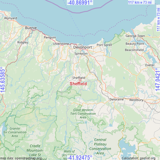
Sheffield GPS coordinates[2]
41° 23' 58.092" South, 146° 20' 20.292" East
| Map corner | latitude | longitude |
|---|---|---|
| Upper-left | -40.86991°, | 145.63585° |
| Center: | -41.39947°, | 146.33897° |
| Lower-right: | -41.92475°, | 147.0421° |
| Map W x H: | 117.3×117.3 km | = 72.9×72.9mi |
| max Lat: | -10.58257° ⇑97.4% North |
| Sheffield: | -41.39947° |
| min Lat: | ⇓2.6% South -43.31423° |
| min Long | Sheffield | max Long |
| 113.53327° | 146.33897° | 153.61246° |
| W 44.1%⇐ | ⇒55.9% E |
Elevation
Elevation of Sheffield is 260 m = 853 ft, and this is 138 m = 453 ft above average elevation for this country.
| Max E: |
1715 m = 5627 ft | 14.3% |
| Sheffield | 260 m 853 ft | |
| Avg. | 122 m = 400 ft | |
Min E: |
-2 m = -7 ft | 85.7% |
See also: Australia elevation on elevation.city.
Geographical zone
Sheffield is located in South temperate zone (between Tropic of Capricorn and the Antarctic Circle). Distance of this Southern Tropic circle is 1997.3 km =1241.1 mi to North.| Distance of | km | miles | from Sheffield |
|---|---|---|---|
| Equator | 4603.2 | 2860.3 | to North |
| Tropic Capricorn | 1997.3 | 1241.1 | to North |
| Antarctic Circle | 2798 | 1738.6 | to South |
| South Pole | 5403.9 | 3357.8 | to South |


Nearby cities:
15 places around Sheffield: (largest is in red/bold)
• Ambleside
22 km =13.7 mi,  7°
7°
• Deloraine
29.9 km =18.6 mi,  117°
117°
• Devonport
24.8 km =15.4 mi,  2°
2°
• Don
25 km =15.5 mi,  356°
356°
• East Devonport
23.9 km =14.9 mi, 9°
• Forth
22.9 km =14.2 mi,  335°
335°
• Gawler
27.5 km =17.1 mi,  326°
326°
• Latrobe
18.5 km =11.5 mi,  22°
22°
• Miandetta
22.7 km =14.1 mi, 3°
• Mole Creek
20.6 km =12.8 mi,  164°
164°
• Railton
9.3 km =5.8 mi,  49°
49°
• Spreyton
18.3 km =11.4 mi, 3°
• Stony Rise
22.7 km =14.1 mi, 358°
• Turners Beach
28 km =17.4 mi, 341°
• Ulverstone
29.6 km =18.4 mi, 333°
Sources, notices
• [Note1] Compared only with cities in Australia existing in our database
• [Src1] Map data: © OpenStreetMap contributors (CC-BY-SA)
• [Src2] Other city data from geonames.org with taken over terms of usage.
• [Src3] Geographical zone / Annual Mean Temperature by Robert A. Rohde @ Wikipedia
