Mole Creek geodata
Mole Creek (Tasmania) is a populated place; located in Australia in Australia/Hobart (GMT+11) time zone. With population of 509 people, there are 4856 cities with bigger population in this country. Compared to other cities in Australia, 97.9% of cities are located further ↑North; 55.6% of cities are located further →East and 87.2% of cities have lower elevation than Mole Creek. Note1


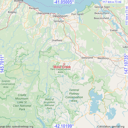
Mole Creek GPS coordinates[2]
41° 34' 41.376" South, 146° 24' 15.192" East
| Map corner | latitude | longitude |
|---|---|---|
| Upper-left | -41.05005°, | 145.7011° |
| Center: | -41.57816°, | 146.40422° |
| Lower-right: | -42.10199°, | 147.10735° |
| Map W x H: | 117×117 km | = 72.7×72.7mi |
| max Lat: | -10.58257° ⇑97.9% North |
| Mole Creek: | -41.57816° |
| min Lat: | ⇓2.1% South -43.31423° |
| min Long | Mole Creek | max Long |
| 113.53327° | 146.40422° | 153.61246° |
| W 44.4%⇐ | ⇒55.6% E |
Elevation
Elevation of Mole Creek is 293 m = 961 ft, and this is 171 m = 561 ft above average elevation for this country.
| Max E: |
1715 m = 5627 ft | 12.8% |
| Mole Creek | 293 m 961 ft | |
| Avg. | 122 m = 400 ft | |
Min E: |
-2 m = -7 ft | 87.2% |
See also: Australia elevation on elevation.city.
Geographical zone
Mole Creek is located in South temperate zone (between Tropic of Capricorn and the Antarctic Circle). Distance of this Southern Tropic circle is 2017.1 km =1253.4 mi to North.| Distance of | km | miles | from Mole Creek |
|---|---|---|---|
| Equator | 4623.1 | 2872.7 | to North |
| Tropic Capricorn | 2017.1 | 1253.4 | to North |
| Antarctic Circle | 2778.1 | 1726.2 | to South |
| South Pole | 5384 | 3345.5 | to South |


Nearby cities:
15 places around Mole Creek: (largest is in red/bold)
• Ambleside
41.8 km =26 mi,  356°
356°
• Deloraine
21.9 km =13.6 mi,  74°
74°
• Devonport
44.8 km =27.8 mi,  354°
354°
• Don
45.4 km =28.2 mi, 350°
• East Devonport
43.4 km =27 mi, 358°
• Forth
43.4 km =27 mi,  340°
340°
• Gawler
47.5 km =29.5 mi,  334°
334°
• Latrobe
36.9 km =22.9 mi,  2°
2°
• Miandetta
42.8 km =26.6 mi, 354°
• Port Sorell
47.4 km =29.5 mi,  15°
15°
• Railton
25.9 km =16.1 mi, 3°
• Sheffield
20.6 km =12.8 mi, 344°
• Spreyton
38.4 km =23.9 mi, 353°
• Stony Rise
43 km =26.7 mi, 351°
• Westbury
36.6 km =22.7 mi,  81°
81°
Sources, notices
• [Note1] Compared only with cities in Australia existing in our database
• [Src1] Map data: © OpenStreetMap contributors (CC-BY-SA)
• [Src2] Other city data from geonames.org with taken over terms of usage.
• [Src3] Geographical zone / Annual Mean Temperature by Robert A. Rohde @ Wikipedia
