Deloraine geodata
Deloraine (Tasmania) is a populated place; located in Australia in Australia/Hobart (GMT+11) time zone. With population of 2,801 people, there are 2376 cities with bigger population in this country. Compared to other cities in Australia, 97.8% of cities are located further ↑North; 55% of cities are located further →East and 84.6% of cities have lower elevation than Deloraine. Note1


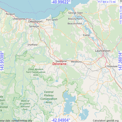
Deloraine GPS coordinates[2]
41° 31' 29.172" South, 146° 39' 25.236" East
| Map corner | latitude | longitude |
|---|---|---|
| Upper-left | -40.99622°, | 145.95389° |
| Center: | -41.52477°, | 146.65701° |
| Lower-right: | -42.04904°, | 147.36014° |
| Map W x H: | 117.1×117.1 km | = 72.8×72.8mi |
| max Lat: | -10.58257° ⇑97.8% North |
| Deloraine: | -41.52477° |
| min Lat: | ⇓2.2% South -43.31423° |
| min Long | Deloraine | max Long |
| 113.53327° | 146.65701° | 153.61246° |
| W 45%⇐ | ⇒55% E |
Elevation
Elevation of Deloraine is 241 m = 791 ft, and this is 119 m = 390 ft above average elevation for this country.
| Max E: |
1715 m = 5627 ft | 15.4% |
| Deloraine | 241 m 791 ft | |
| Avg. | 122 m = 400 ft | |
Min E: |
-2 m = -7 ft | 84.6% |
See also: Australia elevation on elevation.city.
Geographical zone
Deloraine is located in South temperate zone (between Tropic of Capricorn and the Antarctic Circle). Distance of this Southern Tropic circle is 2011.2 km =1249.7 mi to North.| Distance of | km | miles | from Deloraine |
|---|---|---|---|
| Equator | 4617.1 | 2868.9 | to North |
| Tropic Capricorn | 2011.2 | 1249.7 | to North |
| Antarctic Circle | 2784.1 | 1730 | to South |
| South Pole | 5389.9 | 3349.1 | to South |


Nearby cities:
15 places around Deloraine: (largest is in red/bold)
• Beaconsfield
38.3 km =23.8 mi,  20°
20°
• Blackstone Heights
36.3 km =22.6 mi,  78°
78°
• Carrick
29.4 km =18.3 mi,  91°
91°
• Exeter
35.2 km =21.9 mi,  44°
44°
• Gravelly Beach
37.5 km =23.3 mi,  45°
45°
• Grindelwald
34.8 km =21.6 mi,  56°
56°
• Hadspen
34.8 km =21.6 mi, 85°
• Latrobe
36.5 km =22.7 mi,  327°
327°
• Legana
36.9 km =22.9 mi, 61°
• Mole Creek
21.9 km =13.6 mi,  254°
254°
• Prospect Vale
37.5 km =23.3 mi, 82°
• Railton
27.8 km =17.3 mi,  315°
315°
• Riverside
34.8 km =21.6 mi,  70°
70°
• Sheffield
29.9 km =18.6 mi,  297°
297°
• Westbury
15.2 km =9.4 mi, 91°
Sources, notices
• [Note1] Compared only with cities in Australia existing in our database
• [Src1] Map data: © OpenStreetMap contributors (CC-BY-SA)
• [Src2] Other city data from geonames.org with taken over terms of usage.
• [Src3] Geographical zone / Annual Mean Temperature by Robert A. Rohde @ Wikipedia
