Rosebery geodata
Rosebery (Tasmania) is a populated place; located in Australia in Australia/Hobart (GMT+11) time zone. With population of 751 people, there are 4240 cities with bigger population in this country. Compared to other cities in Australia, 98% of cities are located further ↑North; 59.5% of cities are located further →East and 77.6% of cities have lower elevation than Rosebery. Note1


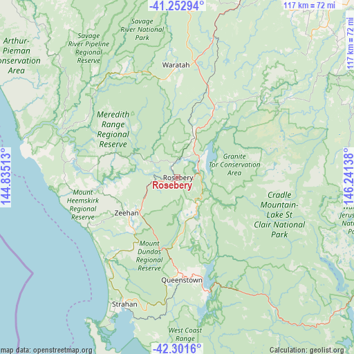
Rosebery GPS coordinates[2]
41° 46' 45.876" South, 145° 32' 17.7" East
| Map corner | latitude | longitude |
|---|---|---|
| Upper-left | -41.25294°, | 144.83513° |
| Center: | -41.77941°, | 145.53825° |
| Lower-right: | -42.3016°, | 146.24138° |
| Map W x H: | 116.6×116.6 km | = 72.5×72.5mi |
| max Lat: | -10.58257° ⇑98% North |
| Rosebery: | -41.77941° |
| min Lat: | ⇓2% South -43.31423° |
| min Long | Rosebery | max Long |
| 113.53327° | 145.53825° | 153.61246° |
| W 40.5%⇐ | ⇒59.5% E |
Elevation
Elevation of Rosebery is 152 m = 499 ft, and this is 30 m = 98 ft above average elevation for this country.
| Max E: |
1715 m = 5627 ft | 22.4% |
| Rosebery | 152 m 499 ft | |
| Avg. | 122 m = 400 ft | |
Min E: |
-2 m = -7 ft | 77.6% |
See also: Australia elevation on elevation.city.
Geographical zone
Rosebery is located in South temperate zone (between Tropic of Capricorn and the Antarctic Circle). Distance of this Southern Tropic circle is 2039.5 km =1267.3 mi to North.| Distance of | km | miles | from Rosebery |
|---|---|---|---|
| Equator | 4645.4 | 2886.5 | to North |
| Tropic Capricorn | 2039.5 | 1267.3 | to North |
| Antarctic Circle | 2755.7 | 1712.3 | to South |
| South Pole | 5361.6 | 3331.5 | to South |


Nearby cities:
15 places around Rosebery: (largest is in red/bold)
• Brooklyn
84.4 km =52.4 mi,  21°
21°
• Forth
85.3 km =53 mi,  42°
42°
• Gawler
83 km =51.6 mi, 38°
• Havenview
83.4 km =51.8 mi, 21°
• Hillcrest
85 km =52.8 mi, 20°
• Mole Creek
75.3 km =46.8 mi,  72°
72°
• Queenstown
33.5 km =20.8 mi,  177°
177°
• Ridgley
73.6 km =45.7 mi, 19°
• Romaine
81.2 km =50.5 mi, 21°
• Sheffield
78.9 km =49 mi,  57°
57°
• Shorewell Park
83.8 km =52.1 mi, 19°
• Strahan
44.9 km =27.9 mi,  202°
202°
• Upper Burnie
84.3 km =52.4 mi, 20°
• West Strahan
45.3 km =28.1 mi, 203°
• Zeehan
20.3 km =12.6 mi,  235°
235°
Sources, notices
• [Note1] Compared only with cities in Australia existing in our database
• [Src1] Map data: © OpenStreetMap contributors (CC-BY-SA)
• [Src2] Other city data from geonames.org with taken over terms of usage.
• [Src3] Geographical zone / Annual Mean Temperature by Robert A. Rohde @ Wikipedia
