Queenstown geodata
Queenstown (Tasmania) is a populated place; located in Australia in Australia/Hobart (GMT+11) time zone. With population of 1,800 people, there are 3045 cities with bigger population in this country. Compared to other cities in Australia, 98.1% of cities are located further ↑North; 59.4% of cities are located further →East and 77% of cities have lower elevation than Queenstown. Note1


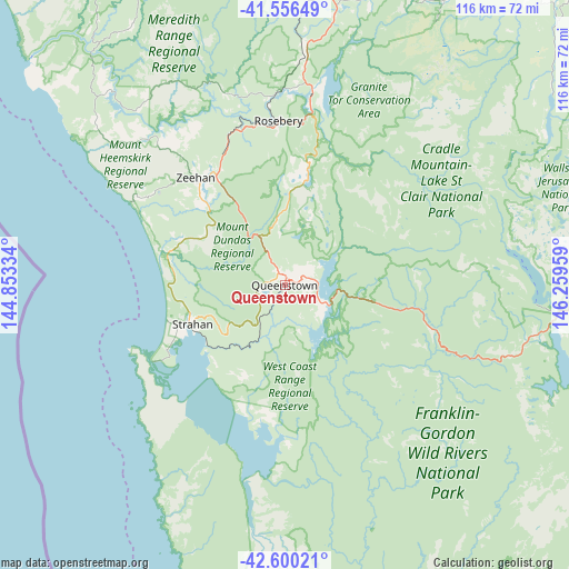
Queenstown GPS coordinates[2]
42° 4' 49.8" South, 145° 33' 23.256" East
| Map corner | latitude | longitude |
|---|---|---|
| Upper-left | -41.55649°, | 144.85334° |
| Center: | -42.0805°, | 145.55646° |
| Lower-right: | -42.60021°, | 146.25959° |
| Map W x H: | 116.1×116 km | = 72.1×72.1mi |
| max Lat: | -10.58257° ⇑98.1% North |
| Queenstown: | -42.0805° |
| min Lat: | ⇓1.9% South -43.31423° |
| min Long | Queenstown | max Long |
| 113.53327° | 145.55646° | 153.61246° |
| W 40.6%⇐ | ⇒59.4% E |
Elevation
Elevation of Queenstown is 148 m = 486 ft, and this is 26 m = 85 ft above average elevation for this country.
| Max E: |
1715 m = 5627 ft | 23% |
| Queenstown | 148 m 486 ft | |
| Avg. | 122 m = 400 ft | |
Min E: |
-2 m = -7 ft | 77% |
See also: Australia elevation on elevation.city.
Geographical zone
Queenstown is located in South temperate zone (between Tropic of Capricorn and the Antarctic Circle). Distance of this Southern Tropic circle is 2073 km =1288.1 mi to North.| Distance of | km | miles | from Queenstown |
|---|---|---|---|
| Equator | 4678.9 | 2907.3 | to North |
| Tropic Capricorn | 2073 | 1288.1 | to North |
| Antarctic Circle | 2722.3 | 1691.6 | to South |
| South Pole | 5328.1 | 3310.7 | to South |


Nearby cities:
15 places around Queenstown: (largest is in red/bold)
• Deloraine
110.2 km =68.5 mi,  55°
55°
• Forth
111.6 km =69.3 mi,  29°
29°
• Gawler
110.5 km =68.7 mi, 26°
• Havenview
114.7 km =71.3 mi,  14°
14°
• Mole Creek
89.7 km =55.7 mi,  51°
51°
• Penguin
114.8 km =71.3 mi,  21°
21°
• Railton
108.9 km =67.7 mi,  41°
41°
• Ridgley
105.4 km =65.5 mi, 12°
• Romaine
112.6 km =70 mi, 14°
• Rosebery
33.5 km =20.8 mi,  357°
357°
• Sheffield
99.7 km =62 mi, 40°
• Strahan
20.5 km =12.7 mi,  247°
247°
• West Strahan
21.3 km =13.2 mi, 248°
• West Ulverstone
114.1 km =70.9 mi, 24°
• Zeehan
28.5 km =17.7 mi,  320°
320°
Sources, notices
• [Note1] Compared only with cities in Australia existing in our database
• [Src1] Map data: © OpenStreetMap contributors (CC-BY-SA)
• [Src2] Other city data from geonames.org with taken over terms of usage.
• [Src3] Geographical zone / Annual Mean Temperature by Robert A. Rohde @ Wikipedia
