Kilmore geodata
Kilmore (Victoria) is a populated place; located in Australia in Australia/Melbourne (GMT+11) time zone. With population of 7,865 people, there are 852 cities with bigger population in this country. Compared to other cities in Australia, 82.1% of cities are located further ↑North; 67.2% of cities are located further →East and 89.3% of cities have lower elevation than Kilmore. Note1


Kilmore GPS coordinates[2]
37° 17' 44.772" South, 144° 57' 9.072" East
| Map corner | latitude | longitude |
|---|---|---|
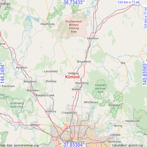
| Upper-left | -36.73435°, | 144.2494° |
| Center: | -37.29577°, | 144.95252° |
| Lower-right: | -37.85304°, | 145.65565° |
| Map W x H: | 124.4×124.4 km | = 77.3×77.3mi |
| max Lat: | -10.58257° ⇑82.1% North |
| Kilmore: | -37.29577° |
| min Lat: | ⇓17.9% South -43.31423° |
| min Long | Kilmore | max Long |
| 113.53327° | 144.95252° | 153.61246° |
| W 32.8%⇐ | ⇒67.2% E |
Elevation
Elevation of Kilmore is 354 m = 1161 ft, and this is 232 m = 761 ft above average elevation for this country.
| Max E: |
1715 m = 5627 ft | 10.7% |
| Kilmore | 354 m 1161 ft | |
| Avg. | 122 m = 400 ft | |
Min E: |
-2 m = -7 ft | 89.3% |
See also: Australia elevation on elevation.city.
Geographical zone
Kilmore is located in South temperate zone (between Tropic of Capricorn and the Antarctic Circle). Distance of this Southern Tropic circle is 1541 km =957.5 mi to North.| Distance of | km | miles | from Kilmore |
|---|---|---|---|
| Equator | 4146.9 | 2576.8 | to North |
| Tropic Capricorn | 1541 | 957.5 | to North |
| Antarctic Circle | 3254.3 | 2022.1 | to South |
| South Pole | 5860.2 | 3641.4 | to South |


Nearby cities:
15 places around Kilmore: (largest is in red/bold)
• Beveridge
21 km =13 mi,  172°
172°
• Broadford
13.4 km =8.3 mi,  39°
39°
• Craigieburn
33.8 km =21 mi,  180°
180°
• Eden Park
23.8 km =14.8 mi,  151°
151°
• Flowerdale
33.9 km =21.1 mi,  97°
97°
• Kinglake West
31.3 km =19.4 mi,  127°
127°
• Lancefield
19.3 km =12 mi,  276°
276°
• Mickleham
27.2 km =16.9 mi,  189°
189°
• Pyalong
22.2 km =13.8 mi,  336°
336°
• Romsey
19.5 km =12.1 mi,  251°
251°
• Tallarook
26 km =16.2 mi,  30°
30°
• Wallan
13.6 km =8.5 mi, 170°
• Wandong
11 km =6.8 mi,  140°
140°
• Whittlesea
28.1 km =17.5 mi, 148°
• Wollert
32.8 km =20.4 mi, 167°
Sources, notices
• [Note1] Compared only with cities in Australia existing in our database
• [Src1] Map data: © OpenStreetMap contributors (CC-BY-SA)
• [Src2] Other city data from geonames.org with taken over terms of usage.
• [Src3] Geographical zone / Annual Mean Temperature by Robert A. Rohde @ Wikipedia
