Peak Hill geodata
Peak Hill (New South Wales) is a populated place; located in Australia in Australia/Sydney (GMT+11) time zone. With population of 1,099 people, there are 3695 cities with bigger population in this country. Compared to other cities in Australia, 60.4% of cities are located further ↓South; 51.3% of cities are located further ←West and 87% of cities have lower elevation than Peak Hill. Note1


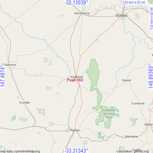
Peak Hill GPS coordinates[2]
32° 43' 25.932" South, 148° 11' 25.872" East
| Map corner | latitude | longitude |
|---|---|---|
| Upper-left | -32.13039°, | 147.4874° |
| Center: | -32.72387°, | 148.19052° |
| Lower-right: | -33.31343°, | 148.89365° |
| Map W x H: | 131.5×131.5 km | = 81.7×81.7mi |
| max Lat: | -10.58257° ⇑39.6% North |
| Peak Hill: | -32.72387° |
| min Lat: | ⇓60.4% South -43.31423° |
| min Long | Peak Hill | max Long |
| 113.53327° | 148.19052° | 153.61246° |
| W 51.3%⇐ | ⇒48.7% E |
Elevation
Elevation of Peak Hill is 287 m = 942 ft, and this is 165 m = 541 ft above average elevation for this country.
| Max E: |
1715 m = 5627 ft | 13% |
| Peak Hill | 287 m 942 ft | |
| Avg. | 122 m = 400 ft | |
Min E: |
-2 m = -7 ft | 87% |
See also: Australia elevation on elevation.city.
Geographical zone
Peak Hill is located in South temperate zone (between Tropic of Capricorn and the Antarctic Circle). Distance of this Southern Tropic circle is 1032.6 km =641.6 mi to North.| Distance of | km | miles | from Peak Hill |
|---|---|---|---|
| Equator | 3638.6 | 2260.9 | to North |
| Tropic Capricorn | 1032.6 | 641.6 | to North |
| Antarctic Circle | 3762.6 | 2338 | to South |
| South Pole | 6368.5 | 3957.2 | to South |


Nearby cities:
15 places around Peak Hill: (largest is in red/bold)
• Cudal
80.8 km =50.2 mi,  140°
140°
• Dubbo
66.1 km =41.1 mi,  36°
36°
• Eugowra
80 km =49.7 mi,  167°
167°
• Eulomogo
68.7 km =42.7 mi, 42°
• Forbes
75.4 km =46.9 mi,  193°
193°
• Geurie
69.9 km =43.4 mi,  59°
59°
• Manildra
69 km =42.9 mi, 137°
• Molong
75.5 km =46.9 mi,  122°
122°
• Montefiores
72.7 km =45.2 mi,  73°
73°
• Narromine
55 km =34.2 mi,  4°
4°
• Parkes
46 km =28.6 mi,  181°
181°
• Trangie
79.4 km =49.3 mi,  345°
345°
• Trundle
50.1 km =31.1 mi,  243°
243°
• Wellington
73.1 km =45.4 mi,  75°
75°
• Wongarbon
68.8 km =42.8 mi,  50°
50°
Sources, notices
• [Note1] Compared only with cities in Australia existing in our database
• [Src1] Map data: © OpenStreetMap contributors (CC-BY-SA)
• [Src2] Other city data from geonames.org with taken over terms of usage.
• [Src3] Geographical zone / Annual Mean Temperature by Robert A. Rohde @ Wikipedia
