Trundle geodata
Trundle (New South Wales) is a populated place; located in Australia in Australia/Sydney (GMT+11) time zone. With population of 654 people, there are 4424 cities with bigger population in this country. Compared to other cities in Australia, 58.5% of cities are located further ↓South; 50.5% of cities are located further ←West and 85.3% of cities have lower elevation than Trundle. Note1


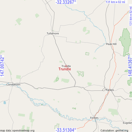
Trundle GPS coordinates[2]
32° 55' 29.352" South, 147° 42' 37.944" East
| Map corner | latitude | longitude |
|---|---|---|
| Upper-left | -32.33267°, | 147.00742° |
| Center: | -32.92482°, | 147.71054° |
| Lower-right: | -33.51304°, | 148.41367° |
| Map W x H: | 131.2×131.2 km | = 81.5×81.5mi |
| max Lat: | -10.58257° ⇑41.5% North |
| Trundle: | -32.92482° |
| min Lat: | ⇓58.5% South -43.31423° |
| min Long | Trundle | max Long |
| 113.53327° | 147.71054° | 153.61246° |
| W 50.5%⇐ | ⇒49.5% E |
Elevation
Elevation of Trundle is 253 m = 830 ft, and this is 131 m = 430 ft above average elevation for this country.
| Max E: |
1715 m = 5627 ft | 14.7% |
| Trundle | 253 m 830 ft | |
| Avg. | 122 m = 400 ft | |
Min E: |
-2 m = -7 ft | 85.3% |
See also: Australia elevation on elevation.city.
Geographical zone
Trundle is located in South temperate zone (between Tropic of Capricorn and the Antarctic Circle). Distance of this Southern Tropic circle is 1055 km =655.5 mi to North.| Distance of | km | miles | from Trundle |
|---|---|---|---|
| Equator | 3660.9 | 2274.8 | to North |
| Tropic Capricorn | 1055 | 655.5 | to North |
| Antarctic Circle | 3740.3 | 2324.1 | to South |
| South Pole | 6346.2 | 3943.3 | to South |


Nearby cities:
15 places around Trundle: (largest is in red/bold)
• Canowindra
113.6 km =70.6 mi,  128°
128°
• Cargo
116.3 km =72.3 mi,  118°
118°
• Condobolin
55.2 km =34.3 mi,  250°
250°
• Cudal
104 km =64.6 mi,  112°
112°
• Dubbo
113 km =70.2 mi,  47°
47°
• Eugowra
83.1 km =51.6 mi, 132°
• Forbes
58.1 km =36.1 mi,  151°
151°
• Grenfell
115.9 km =72 mi,  158°
158°
• Manildra
95.6 km =59.4 mi, 107°
• Molong
109.7 km =68.2 mi,  99°
99°
• Narromine
91.7 km =57 mi,  32°
32°
• Parkes
49.4 km =30.7 mi, 118°
• Peak Hill
50.1 km =31.1 mi,  63°
63°
• Trangie
102.6 km =63.8 mi,  14°
14°
• Ungarie
105 km =65.2 mi,  220°
220°
Sources, notices
• [Note1] Compared only with cities in Australia existing in our database
• [Src1] Map data: © OpenStreetMap contributors (CC-BY-SA)
• [Src2] Other city data from geonames.org with taken over terms of usage.
• [Src3] Geographical zone / Annual Mean Temperature by Robert A. Rohde @ Wikipedia
