Dubbo geodata
Dubbo (New South Wales) is a populated place; located in Australia in Australia/Sydney (GMT+11) time zone. With population of 39,863 people, there are 39 cities with bigger population in this country. Compared to other cities in Australia, 62.5% of cities are located further ↓South; 51.8% of cities are located further ←West and 85.9% of cities have lower elevation than Dubbo. Note1


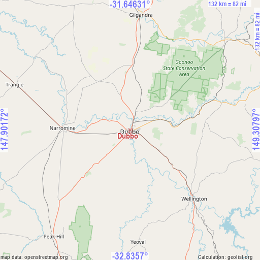
Dubbo GPS coordinates[2]
32° 14' 34.62" South, 148° 36' 17.424" East
| Map corner | latitude | longitude |
|---|---|---|
| Upper-left | -31.64631°, | 147.90172° |
| Center: | -32.24295°, | 148.60484° |
| Lower-right: | -32.8357°, | 149.30797° |
| Map W x H: | 132.2×132.2 km | = 82.1×82.1mi |
| max Lat: | -10.58257° ⇑37.5% North |
| Dubbo: | -32.24295° |
| min Lat: | ⇓62.5% South -43.31423° |
| min Long | Dubbo | max Long |
| 113.53327° | 148.60484° | 153.61246° |
| W 51.8%⇐ | ⇒48.2% E |
Elevation
Elevation of Dubbo is 264 m = 866 ft, and this is 142 m = 466 ft above average elevation for this country.
| Max E: |
1715 m = 5627 ft | 14.1% |
| Dubbo | 264 m 866 ft | |
| Avg. | 122 m = 400 ft | |
Min E: |
-2 m = -7 ft | 85.9% |
See also: Australia elevation on elevation.city.
Geographical zone
Dubbo is located in South temperate zone (between Tropic of Capricorn and the Antarctic Circle). Distance of this Southern Tropic circle is 979.2 km =608.4 mi to North.| Distance of | km | miles | from Dubbo |
|---|---|---|---|
| Equator | 3585.1 | 2227.7 | to North |
| Tropic Capricorn | 979.2 | 608.4 | to North |
| Antarctic Circle | 3816.1 | 2371.2 | to South |
| South Pole | 6422 | 3990.4 | to South |


Nearby cities:
15 places around Dubbo: (largest is in red/bold)
• Dunedoo
77.8 km =48.3 mi,  71°
71°
• Eulomogo
7.8 km =4.8 mi,  109°
109°
• Geurie
27.5 km =17.1 mi,  129°
129°
• Gilgandra
59.3 km =36.8 mi,  5°
5°
• Gulgong
88.1 km =54.7 mi,  98°
98°
• Mendooran
67.5 km =41.9 mi,  46°
46°
• Molong
97.6 km =60.6 mi,  165°
165°
• Montefiores
44.7 km =27.8 mi,  136°
136°
• Narromine
34.3 km =21.3 mi,  272°
272°
• Peak Hill
66.1 km =41.1 mi,  216°
216°
• Trangie
63.1 km =39.2 mi,  291°
291°
• Warren
94.4 km =58.7 mi,  309°
309°
• Wellington
47.2 km =29.3 mi, 137°
• Wongarbon
17.6 km =10.9 mi,  124°
124°
• Wuuluman
56.4 km =35 mi, 127°
Sources, notices
• [Note1] Compared only with cities in Australia existing in our database
• [Src1] Map data: © OpenStreetMap contributors (CC-BY-SA)
• [Src2] Other city data from geonames.org with taken over terms of usage.
• [Src3] Geographical zone / Annual Mean Temperature by Robert A. Rohde @ Wikipedia
