Wellington geodata
Wellington (New South Wales) is a populated place; located in Australia in Australia/Sydney (GMT+11) time zone. With population of 4,075 people, there are 1761 cities with bigger population in this country. Compared to other cities in Australia, 61.2% of cities are located further ↓South; 52.6% of cities are located further ←West and 87.6% of cities have lower elevation than Wellington. Note1


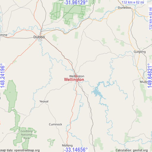
Wellington GPS coordinates[2]
32° 33' 21.168" South, 148° 56' 42.288" East
| Map corner | latitude | longitude |
|---|---|---|
| Upper-left | -31.96129°, | 148.24196° |
| Center: | -32.55588°, | 148.94508° |
| Lower-right: | -33.14656°, | 149.64821° |
| Map W x H: | 131.8×131.8 km | = 81.9×81.9mi |
| max Lat: | -10.58257° ⇑38.8% North |
| Wellington: | -32.55588° |
| min Lat: | ⇓61.2% South -43.31423° |
| min Long | Wellington | max Long |
| 113.53327° | 148.94508° | 153.61246° |
| W 52.6%⇐ | ⇒47.4% E |
Elevation
Elevation of Wellington is 304 m = 997 ft, and this is 182 m = 597 ft above average elevation for this country.
| Max E: |
1715 m = 5627 ft | 12.4% |
| Wellington | 304 m 997 ft | |
| Avg. | 122 m = 400 ft | |
Min E: |
-2 m = -7 ft | 87.6% |
See also: Australia elevation on elevation.city.
Geographical zone
Wellington is located in South temperate zone (between Tropic of Capricorn and the Antarctic Circle). Distance of this Southern Tropic circle is 1014 km =630.1 mi to North.| Distance of | km | miles | from Wellington |
|---|---|---|---|
| Equator | 3619.9 | 2249.3 | to North |
| Tropic Capricorn | 1014 | 630.1 | to North |
| Antarctic Circle | 3781.3 | 2349.6 | to South |
| South Pole | 6387.2 | 3968.8 | to South |


Nearby cities:
15 places around Wellington: (largest is in red/bold)
• Cooks Gap
75.3 km =46.8 mi,  72°
72°
• Dubbo
47.2 km =29.3 mi,  317°
317°
• Dunedoo
73 km =45.4 mi,  34°
34°
• Eulomogo
40.5 km =25.2 mi, 322°
• Geurie
20.3 km =12.6 mi,  328°
328°
• Gulgong
59.1 km =36.7 mi, 68°
• Manildra
73.7 km =45.8 mi,  198°
198°
• Molong
60.1 km =37.3 mi,  186°
186°
• Montefiores
2.7 km =1.7 mi,  336°
336°
• Mudgee
60.3 km =37.5 mi,  94°
94°
• Mullion Creek
65.6 km =40.8 mi,  164°
164°
• Narromine
75.4 km =46.9 mi,  298°
298°
• Peak Hill
73.1 km =45.4 mi,  255°
255°
• Wongarbon
30.3 km =18.8 mi, 324°
• Wuuluman
13 km =8.1 mi, 87°
Sources, notices
• [Note1] Compared only with cities in Australia existing in our database
• [Src1] Map data: © OpenStreetMap contributors (CC-BY-SA)
• [Src2] Other city data from geonames.org with taken over terms of usage.
• [Src3] Geographical zone / Annual Mean Temperature by Robert A. Rohde @ Wikipedia
