Wongarbon geodata
Wongarbon (New South Wales) is a populated place; located in Australia in Australia/Sydney (GMT+11) time zone. With population of 757 people, there are 4231 cities with bigger population in this country. Compared to other cities in Australia, 62.2% of cities are located further ↓South; 52.3% of cities are located further ←West and 90.4% of cities have lower elevation than Wongarbon. Note1


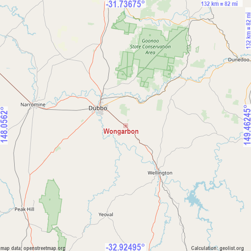
Wongarbon GPS coordinates[2]
32° 19' 58.08" South, 148° 45' 33.552" East
| Map corner | latitude | longitude |
|---|---|---|
| Upper-left | -31.73675°, | 148.0562° |
| Center: | -32.3328°, | 148.75932° |
| Lower-right: | -32.92495°, | 149.46245° |
| Map W x H: | 132.1×132.1 km | = 82.1×82.1mi |
| max Lat: | -10.58257° ⇑37.8% North |
| Wongarbon: | -32.3328° |
| min Lat: | ⇓62.2% South -43.31423° |
| min Long | Wongarbon | max Long |
| 113.53327° | 148.75932° | 153.61246° |
| W 52.3%⇐ | ⇒47.7% E |
Elevation
Elevation of Wongarbon is 390 m = 1280 ft, and this is 268 m = 879 ft above average elevation for this country.
| Max E: |
1715 m = 5627 ft | 9.6% |
| Wongarbon | 390 m 1280 ft | |
| Avg. | 122 m = 400 ft | |
Min E: |
-2 m = -7 ft | 90.4% |
See also: Australia elevation on elevation.city.
Geographical zone
Wongarbon is located in South temperate zone (between Tropic of Capricorn and the Antarctic Circle). Distance of this Southern Tropic circle is 989.2 km =614.7 mi to North.| Distance of | km | miles | from Wongarbon |
|---|---|---|---|
| Equator | 3595.1 | 2233.9 | to North |
| Tropic Capricorn | 989.2 | 614.7 | to North |
| Antarctic Circle | 3806.1 | 2365 | to South |
| South Pole | 6412 | 3984.2 | to South |


Nearby cities:
15 places around Wongarbon: (largest is in red/bold)
• Dubbo
17.6 km =10.9 mi,  304°
304°
• Dunedoo
68.8 km =42.8 mi,  59°
59°
• Eulomogo
10.3 km =6.4 mi,  315°
315°
• Geurie
10.1 km =6.3 mi,  138°
138°
• Gilgandra
69.7 km =43.3 mi,  352°
352°
• Gulgong
72.7 km =45.2 mi,  92°
92°
• Mendooran
66.2 km =41.1 mi,  31°
31°
• Molong
85.1 km =52.9 mi,  173°
173°
• Montefiores
27.6 km =17.1 mi, 143°
• Mudgee
82.9 km =51.5 mi,  110°
110°
• Narromine
50.1 km =31.1 mi,  283°
283°
• Peak Hill
68.8 km =42.8 mi,  230°
230°
• Trangie
80.3 km =49.9 mi,  294°
294°
• Wellington
30.3 km =18.8 mi, 144°
• Wuuluman
38.8 km =24.1 mi,  128°
128°
Sources, notices
• [Note1] Compared only with cities in Australia existing in our database
• [Src1] Map data: © OpenStreetMap contributors (CC-BY-SA)
• [Src2] Other city data from geonames.org with taken over terms of usage.
• [Src3] Geographical zone / Annual Mean Temperature by Robert A. Rohde @ Wikipedia
