Narromine geodata
Narromine (New South Wales) is a populated place; located in Australia in Australia/Sydney (GMT+11) time zone. With population of 4,602 people, there are 1598 cities with bigger population in this country. Compared to other cities in Australia, 62.7% of cities are located further ↓South; 51.4% of cities are located further ←West and 84.6% of cities have lower elevation than Narromine. Note1


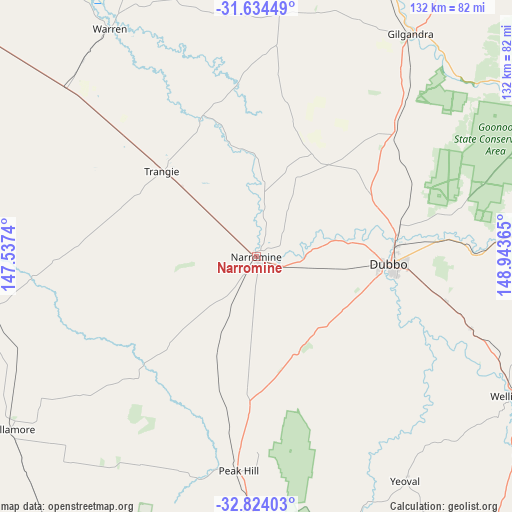
Narromine GPS coordinates[2]
32° 13' 52.356" South, 148° 14' 25.872" East
| Map corner | latitude | longitude |
|---|---|---|
| Upper-left | -31.63449°, | 147.5374° |
| Center: | -32.23121°, | 148.24052° |
| Lower-right: | -32.82403°, | 148.94365° |
| Map W x H: | 132.3×132.3 km | = 82.2×82.2mi |
| max Lat: | -10.58257° ⇑37.3% North |
| Narromine: | -32.23121° |
| min Lat: | ⇓62.7% South -43.31423° |
| min Long | Narromine | max Long |
| 113.53327° | 148.24052° | 153.61246° |
| W 51.4%⇐ | ⇒48.6% E |
Elevation
Elevation of Narromine is 241 m = 791 ft, and this is 119 m = 390 ft above average elevation for this country.
| Max E: |
1715 m = 5627 ft | 15.4% |
| Narromine | 241 m 791 ft | |
| Avg. | 122 m = 400 ft | |
Min E: |
-2 m = -7 ft | 84.6% |
See also: Australia elevation on elevation.city.
Geographical zone
Narromine is located in South temperate zone (between Tropic of Capricorn and the Antarctic Circle). Distance of this Southern Tropic circle is 977.9 km =607.6 mi to North.| Distance of | km | miles | from Narromine |
|---|---|---|---|
| Equator | 3583.8 | 2226.9 | to North |
| Tropic Capricorn | 977.9 | 607.6 | to North |
| Antarctic Circle | 3817.4 | 2372 | to South |
| South Pole | 6423.3 | 3991.3 | to South |


Nearby cities:
15 places around Narromine: (largest is in red/bold)
• Dubbo
34.3 km =21.3 mi,  92°
92°
• Eulomogo
41.8 km =26 mi,  95°
95°
• Geurie
58.5 km =36.4 mi,  108°
108°
• Gilgandra
70.1 km =43.6 mi,  34°
34°
• Gulargambone
102 km =63.4 mi,  12°
12°
• Mendooran
94.7 km =58.8 mi,  61°
61°
• Montefiores
73.2 km =45.5 mi,  117°
117°
• Parkes
100.9 km =62.7 mi,  183°
183°
• Peak Hill
55 km =34.2 mi, 184°
• Trangie
32.9 km =20.4 mi,  312°
312°
• Trundle
91.7 km =57 mi,  212°
212°
• Warren
70.2 km =43.6 mi,  326°
326°
• Wellington
75.4 km =46.9 mi, 118°
• Wongarbon
50.1 km =31.1 mi, 103°
• Wuuluman
86.7 km =53.9 mi, 114°
Sources, notices
• [Note1] Compared only with cities in Australia existing in our database
• [Src1] Map data: © OpenStreetMap contributors (CC-BY-SA)
• [Src2] Other city data from geonames.org with taken over terms of usage.
• [Src3] Geographical zone / Annual Mean Temperature by Robert A. Rohde @ Wikipedia
