Forbes geodata
Forbes (New South Wales) is a populated place; located in Australia in Australia/Sydney (GMT+11) time zone. With population of 8,481 people, there are 768 cities with bigger population in this country. Compared to other cities in Australia, 54.6% of cities are located further ↓South; 50.9% of cities are located further ←West and 84.8% of cities have lower elevation than Forbes. Note1


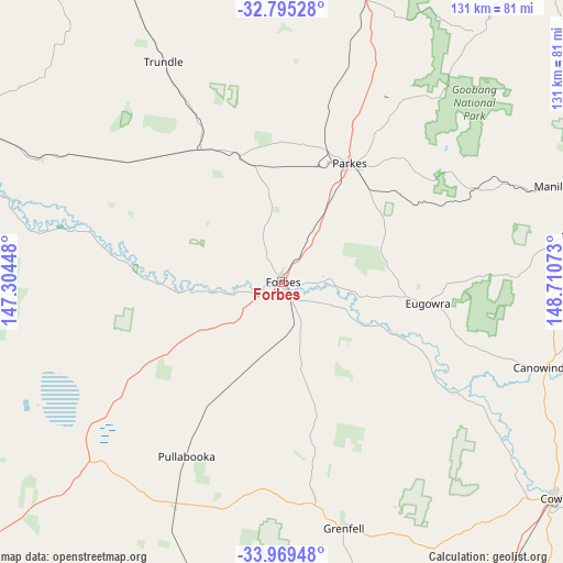
Forbes GPS coordinates[2]
33° 23' 3.696" South, 148° 0' 27.36" East
| Map corner | latitude | longitude |
|---|---|---|
| Upper-left | -32.79528°, | 147.30448° |
| Center: | -33.38436°, | 148.0076° |
| Lower-right: | -33.96948°, | 148.71073° |
| Map W x H: | 130.6×130.6 km | = 81.2×81.2mi |
| max Lat: | -10.58257° ⇑45.4% North |
| Forbes: | -33.38436° |
| min Lat: | ⇓54.6% South -43.31423° |
| min Long | Forbes | max Long |
| 113.53327° | 148.0076° | 153.61246° |
| W 50.9%⇐ | ⇒49.1% E |
Elevation
Elevation of Forbes is 243 m = 797 ft, and this is 121 m = 397 ft above average elevation for this country.
| Max E: |
1715 m = 5627 ft | 15.2% |
| Forbes | 243 m 797 ft | |
| Avg. | 122 m = 400 ft | |
Min E: |
-2 m = -7 ft | 84.8% |
See also: Australia elevation on elevation.city.
Geographical zone
Forbes is located in South temperate zone (between Tropic of Capricorn and the Antarctic Circle). Distance of this Southern Tropic circle is 1106.1 km =687.3 mi to North.| Distance of | km | miles | from Forbes |
|---|---|---|---|
| Equator | 3712 | 2306.5 | to North |
| Tropic Capricorn | 1106.1 | 687.3 | to North |
| Antarctic Circle | 3689.2 | 2292.4 | to South |
| South Pole | 6295.1 | 3911.6 | to South |


Nearby cities:
15 places around Forbes: (largest is in red/bold)
• Canowindra
64 km =39.8 mi,  108°
108°
• Cargo
74.5 km =46.3 mi,  93°
93°
• Condobolin
86.1 km =53.5 mi,  292°
292°
• Cowra
81.2 km =50.5 mi,  128°
128°
• Cudal
69 km =42.9 mi,  80°
80°
• Eugowra
34.1 km =21.2 mi,  98°
98°
• Grenfell
58.7 km =36.5 mi,  165°
165°
• Manildra
67.2 km =41.8 mi,  70°
70°
• Molong
86.5 km =53.7 mi, 67°
• Parkes
31.6 km =19.6 mi,  29°
29°
• Peak Hill
75.4 km =46.9 mi,  13°
13°
• Trundle
58.1 km =36.1 mi,  331°
331°
• West Wyalong
95.5 km =59.3 mi,  231°
231°
• Woodstock
87.6 km =54.4 mi,  117°
117°
• Wyalong
92.9 km =57.7 mi, 229°
Sources, notices
• [Note1] Compared only with cities in Australia existing in our database
• [Src1] Map data: © OpenStreetMap contributors (CC-BY-SA)
• [Src2] Other city data from geonames.org with taken over terms of usage.
• [Src3] Geographical zone / Annual Mean Temperature by Robert A. Rohde @ Wikipedia
