Sea Lake geodata
Sea Lake (Victoria) is a populated place; located in Australia in Australia/Melbourne (GMT+11) time zone. With population of 628 people, there are 4495 cities with bigger population in this country. Compared to other cities in Australia, 77.1% of cities are located further ↑North; 74.1% of cities are located further →East and 58.5% of cities have lower elevation than Sea Lake. Note1


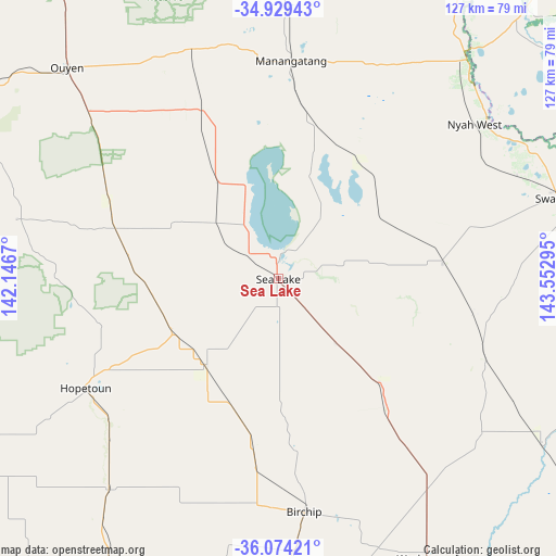
Sea Lake GPS coordinates[2]
35° 30' 13.896" South, 142° 50' 59.352" East
| Map corner | latitude | longitude |
|---|---|---|
| Upper-left | -34.92943°, | 142.1467° |
| Center: | -35.50386°, | 142.84982° |
| Lower-right: | -36.07421°, | 143.55295° |
| Map W x H: | 127.3×127.3 km | = 79.1×79.1mi |
| max Lat: | -10.58257° ⇑77.1% North |
| Sea Lake: | -35.50386° |
| min Lat: | ⇓22.9% South -43.31423° |
| min Long | Sea Lake | max Long |
| 113.53327° | 142.84982° | 153.61246° |
| W 25.9%⇐ | ⇒74.1% E |
Elevation
Elevation of Sea Lake is 60 m = 197 ft, and this is 62 m = 203 ft below average elevation for this country.
| Max E: |
1715 m = 5627 ft | 41.5% |
| Avg. | 122 m = 400 ft | |
| Sea Lake | 60 m = 197 ft | |
Min E: |
-2 m = -7 ft | 58.5% |
See also: Australia elevation on elevation.city.
Geographical zone
Sea Lake is located in South temperate zone (between Tropic of Capricorn and the Antarctic Circle). Distance of this Southern Tropic circle is 1341.7 km =833.7 mi to North.| Distance of | km | miles | from Sea Lake |
|---|---|---|---|
| Equator | 3947.7 | 2453 | to North |
| Tropic Capricorn | 1341.7 | 833.7 | to North |
| Antarctic Circle | 3453.5 | 2145.9 | to South |
| South Pole | 6059.4 | 3765.1 | to South |


Nearby cities:
15 places around Sea Lake: (largest is in red/bold)
• Birchip
53.7 km =33.4 mi,  173°
173°
• Boort
103.8 km =64.5 mi,  130°
130°
• Charlton
95.8 km =59.5 mi,  151°
151°
• Donald
96.9 km =60.2 mi, 172°
• Hopetoun
50.3 km =31.3 mi,  240°
240°
• Kerang
100.1 km =62.2 mi,  104°
104°
• Lake Boga
71 km =44.1 mi,  86°
86°
• Nyah
60.2 km =37.4 mi,  52°
52°
• Nyah West
57.6 km =35.8 mi, 52°
• Ouyen
68 km =42.3 mi,  315°
315°
• Rainbow
88.4 km =54.9 mi, 240°
• Robinvale
102.6 km =63.8 mi,  356°
356°
• Swan Hill
66.5 km =41.3 mi,  73°
73°
• Warracknabeal
92.9 km =57.7 mi,  206°
206°
• Wycheproof
72.3 km =44.9 mi, 151°
Sources, notices
• [Note1] Compared only with cities in Australia existing in our database
• [Src1] Map data: © OpenStreetMap contributors (CC-BY-SA)
• [Src2] Other city data from geonames.org with taken over terms of usage.
• [Src3] Geographical zone / Annual Mean Temperature by Robert A. Rohde @ Wikipedia
