Nyah West geodata
Nyah West (Victoria) is a populated place; located in Australia in Australia/Melbourne (GMT+11) time zone. With population of 670 people, there are 4382 cities with bigger population in this country. Compared to other cities in Australia, 74.1% of cities are located further ↑North; 73.8% of cities are located further →East and 65.3% of cities have lower elevation than Nyah West. Note1


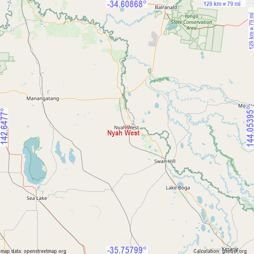
Nyah West GPS coordinates[2]
35° 11' 7.332" South, 143° 21' 2.952" East
| Map corner | latitude | longitude |
|---|---|---|
| Upper-left | -34.60868°, | 142.6477° |
| Center: | -35.18537°, | 143.35082° |
| Lower-right: | -35.75799°, | 144.05395° |
| Map W x H: | 127.8×127.8 km | = 79.4×79.4mi |
| max Lat: | -10.58257° ⇑74.1% North |
| Nyah West: | -35.18537° |
| min Lat: | ⇓25.9% South -43.31423° |
| min Long | Nyah West | max Long |
| 113.53327° | 143.35082° | 153.61246° |
| W 26.2%⇐ | ⇒73.8% E |
Elevation
Elevation of Nyah West is 81 m = 266 ft, and this is 41 m = 135 ft below average elevation for this country.
| Max E: |
1715 m = 5627 ft | 34.7% |
| Avg. | 122 m = 400 ft | |
| Nyah West | 81 m = 266 ft | |
Min E: |
-2 m = -7 ft | 65.3% |
See also: Australia elevation on elevation.city.
Geographical zone
Nyah West is located in South temperate zone (between Tropic of Capricorn and the Antarctic Circle). Distance of this Southern Tropic circle is 1306.3 km =811.7 mi to North.| Distance of | km | miles | from Nyah West |
|---|---|---|---|
| Equator | 3912.2 | 2430.9 | to North |
| Tropic Capricorn | 1306.3 | 811.7 | to North |
| Antarctic Circle | 3488.9 | 2167.9 | to South |
| South Pole | 6094.8 | 3787.1 | to South |


Nearby cities:
15 places around Nyah West: (largest is in red/bold)
• Balranald
64 km =39.8 mi,  17°
17°
• Barham
85.9 km =53.4 mi,  124°
124°
• Birchip
97 km =60.3 mi,  203°
203°
• Cohuna
104.6 km =65 mi,  131°
131°
• Euston
87.6 km =54.4 mi,  320°
320°
• Hopetoun
107.6 km =66.9 mi,  235°
235°
• Kerang
80 km =49.7 mi,  139°
139°
• Koondrook
85.9 km =53.4 mi, 125°
• Lake Boga
40.1 km =24.9 mi, 140°
• Nyah
2.7 km =1.7 mi,  65°
65°
• Ouyen
94.6 km =58.8 mi,  277°
277°
• Robinvale
85.2 km =52.9 mi, 321°
• Sea Lake
57.6 km =35.8 mi,  232°
232°
• Swan Hill
25.1 km =15.6 mi, 132°
• Wycheproof
99.8 km =62 mi,  186°
186°
Sources, notices
• [Note1] Compared only with cities in Australia existing in our database
• [Src1] Map data: © OpenStreetMap contributors (CC-BY-SA)
• [Src2] Other city data from geonames.org with taken over terms of usage.
• [Src3] Geographical zone / Annual Mean Temperature by Robert A. Rohde @ Wikipedia
