Hopetoun geodata
Hopetoun (Victoria) is a populated place; located in Australia in Australia/Melbourne (GMT+11) time zone. With population of 719 people, there are 4293 cities with bigger population in this country. Compared to other cities in Australia, 77.7% of cities are located further ↑North; 74.5% of cities are located further →East and 64.9% of cities have lower elevation than Hopetoun. Note1


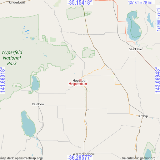
Hopetoun GPS coordinates[2]
35° 43' 37.272" South, 142° 21' 58.68" East
| Map corner | latitude | longitude |
|---|---|---|
| Upper-left | -35.15418°, | 141.66318° |
| Center: | -35.72702°, | 142.3663° |
| Lower-right: | -36.29577°, | 143.06943° |
| Map W x H: | 126.9×126.9 km | = 78.9×78.9mi |
| max Lat: | -10.58257° ⇑77.7% North |
| Hopetoun: | -35.72702° |
| min Lat: | ⇓22.3% South -43.31423° |
| min Long | Hopetoun | max Long |
| 113.53327° | 142.3663° | 153.61246° |
| W 25.5%⇐ | ⇒74.5% E |
Elevation
Elevation of Hopetoun is 80 m = 262 ft, and this is 42 m = 138 ft below average elevation for this country.
| Max E: |
1715 m = 5627 ft | 35.1% |
| Avg. | 122 m = 400 ft | |
| Hopetoun | 80 m = 262 ft | |
Min E: |
-2 m = -7 ft | 64.9% |
See also: Australia elevation on elevation.city.
Geographical zone
Hopetoun is located in South temperate zone (between Tropic of Capricorn and the Antarctic Circle). Distance of this Southern Tropic circle is 1366.6 km =849.2 mi to North.| Distance of | km | miles | from Hopetoun |
|---|---|---|---|
| Equator | 3972.5 | 2468.4 | to North |
| Tropic Capricorn | 1366.6 | 849.2 | to North |
| Antarctic Circle | 3428.7 | 2130.5 | to South |
| South Pole | 6034.6 | 3749.7 | to South |


Nearby cities:
15 places around Hopetoun: (largest is in red/bold)
• Birchip
57.3 km =35.6 mi,  119°
119°
• Charlton
106.7 km =66.3 mi, 124°
• Dimboola
86.4 km =53.7 mi,  200°
200°
• Donald
90.2 km =56 mi,  142°
142°
• Horsham
110.5 km =68.7 mi,  187°
187°
• Murtoa
99.7 km =62 mi,  174°
174°
• Nhill
93.2 km =57.9 mi,  223°
223°
• Nyah
110.2 km =68.5 mi,  56°
56°
• Nyah West
107.6 km =66.9 mi, 55°
• Ouyen
73.1 km =45.4 mi,  356°
356°
• Rainbow
38.2 km =23.7 mi,  240°
240°
• Rupanyup
103 km =64 mi, 166°
• Sea Lake
50.3 km =31.3 mi, 60°
• Warracknabeal
58.6 km =36.4 mi,  177°
177°
• Wycheproof
86.8 km =53.9 mi, 116°
Sources, notices
• [Note1] Compared only with cities in Australia existing in our database
• [Src1] Map data: © OpenStreetMap contributors (CC-BY-SA)
• [Src2] Other city data from geonames.org with taken over terms of usage.
• [Src3] Geographical zone / Annual Mean Temperature by Robert A. Rohde @ Wikipedia
