Rainbow geodata
Rainbow (Victoria) is a populated place; located in Australia in Australia/Melbourne (GMT+11) time zone. With population of 664 people, there are 4398 cities with bigger population in this country. Compared to other cities in Australia, 78.1% of cities are located further ↑North; 75% of cities are located further →East and 66.3% of cities have lower elevation than Rainbow. Note1


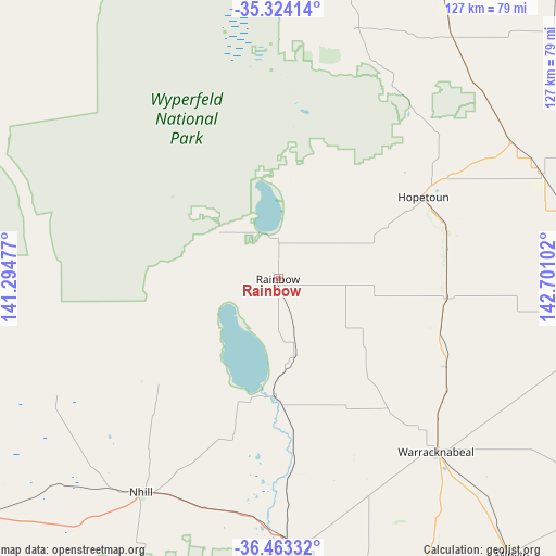
Rainbow GPS coordinates[2]
35° 53' 44.808" South, 141° 59' 52.404" East
| Map corner | latitude | longitude |
|---|---|---|
| Upper-left | -35.32414°, | 141.29477° |
| Center: | -35.89578°, | 141.99789° |
| Lower-right: | -36.46332°, | 142.70102° |
| Map W x H: | 126.7×126.7 km | = 78.7×78.7mi |
| max Lat: | -10.58257° ⇑78.1% North |
| Rainbow: | -35.89578° |
| min Lat: | ⇓21.9% South -43.31423° |
| min Long | Rainbow | max Long |
| 113.53327° | 141.99789° | 153.61246° |
| W 25%⇐ | ⇒75% E |
Elevation
Elevation of Rainbow is 85 m = 279 ft, and this is 37 m = 121 ft below average elevation for this country.
| Max E: |
1715 m = 5627 ft | 33.7% |
| Avg. | 122 m = 400 ft | |
| Rainbow | 85 m = 279 ft | |
Min E: |
-2 m = -7 ft | 66.3% |
See also: Australia elevation on elevation.city.
Geographical zone
Rainbow is located in South temperate zone (between Tropic of Capricorn and the Antarctic Circle). Distance of this Southern Tropic circle is 1385.3 km =860.8 mi to North.| Distance of | km | miles | from Rainbow |
|---|---|---|---|
| Equator | 3991.2 | 2480 | to North |
| Tropic Capricorn | 1385.3 | 860.8 | to North |
| Antarctic Circle | 3409.9 | 2118.8 | to South |
| South Pole | 6015.8 | 3738 | to South |


Nearby cities:
15 places around Rainbow: (largest is in red/bold)
• Birchip
83.3 km =51.8 mi,  96°
96°
• Bordertown
119.3 km =74.1 mi,  247°
247°
• Dimboola
62.4 km =38.8 mi,  177°
177°
• Donald
102.8 km =63.9 mi,  120°
120°
• Haven
97.8 km =60.8 mi,  169°
169°
• Hopetoun
38.2 km =23.7 mi,  60°
60°
• Horsham
92.5 km =57.5 mi, 168°
• Kaniva
86.5 km =53.7 mi,  231°
231°
• Murtoa
90.8 km =56.4 mi,  152°
152°
• Nhill
57.8 km =35.9 mi,  212°
212°
• Ouyen
96.3 km =59.8 mi,  17°
17°
• Rupanyup
99.3 km =61.7 mi, 145°
• Sea Lake
88.4 km =54.9 mi, 60°
• Warracknabeal
53.3 km =33.1 mi,  138°
138°
• Wycheproof
112.4 km =69.8 mi, 100°
Sources, notices
• [Note1] Compared only with cities in Australia existing in our database
• [Src1] Map data: © OpenStreetMap contributors (CC-BY-SA)
• [Src2] Other city data from geonames.org with taken over terms of usage.
• [Src3] Geographical zone / Annual Mean Temperature by Robert A. Rohde @ Wikipedia
