Mitchell geodata
Mitchell (New South Wales) is a populated place; located in Australia in Australia/Sydney (GMT+11) time zone. With population of 628 people, there are 4495 cities with bigger population in this country. Compared to other cities in Australia, 72.6% of cities are located further ↓South; 83.1% of cities are located further ←West and 93.2% of cities have lower elevation than Mitchell. Note1


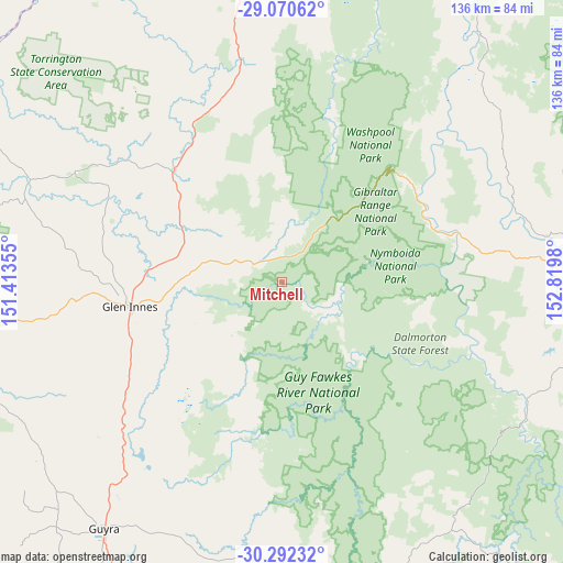
Mitchell GPS coordinates[2]
29° 40' 59.988" South, 152° 7' 0.012" East
| Map corner | latitude | longitude |
|---|---|---|
| Upper-left | -29.07062°, | 151.41355° |
| Center: | -29.68333°, | 152.11667° |
| Lower-right: | -30.29232°, | 152.8198° |
| Map W x H: | 135.8×135.8 km | = 84.4×84.4mi |
| max Lat: | -10.58257° ⇑27.4% North |
| Mitchell: | -29.68333° |
| min Lat: | ⇓72.6% South -43.31423° |
| min Long | Mitchell | max Long |
| 113.53327° | 152.11667° | 153.61246° |
| W 83.1%⇐ | ⇒16.9% E |
Elevation
Elevation of Mitchell is 486 m = 1594 ft, and this is 364 m = 1194 ft above average elevation for this country.
| Max E: |
1715 m = 5627 ft | 6.8% |
| Mitchell | 486 m 1594 ft | |
| Avg. | 122 m = 400 ft | |
Min E: |
-2 m = -7 ft | 93.2% |
See also: Australia elevation on elevation.city.
Geographical zone
Mitchell is located in South temperate zone (between Tropic of Capricorn and the Antarctic Circle). Distance of this Southern Tropic circle is 694.6 km =431.6 mi to North.| Distance of | km | miles | from Mitchell |
|---|---|---|---|
| Equator | 3300.5 | 2050.8 | to North |
| Tropic Capricorn | 694.6 | 431.6 | to North |
| Antarctic Circle | 4100.7 | 2548.1 | to South |
| South Pole | 6706.6 | 4167.3 | to South |


Nearby cities:
15 places around Mitchell: (largest is in red/bold)
• Carrolls Creek
95.7 km =59.5 mi,  359°
359°
• Clarenza
85.4 km =53.1 mi,  91°
91°
• Coutts Crossing
76.5 km =47.5 mi,  101°
101°
• Dorrigo
93 km =57.8 mi,  141°
141°
• Emmaville
56.8 km =35.3 mi,  297°
297°
• Glen Innes
37 km =23 mi,  261°
261°
• Glenreagh
92.7 km =57.6 mi,  116°
116°
• Grafton
78.9 km =49 mi, 89°
• Guyra
73.4 km =45.6 mi,  216°
216°
• Junction Hill
78.2 km =48.6 mi, 86°
• South Grafton
78.2 km =48.6 mi, 91°
• Tenterfield
71.1 km =44.2 mi,  352°
352°
• Tingha
92.3 km =57.4 mi,  250°
250°
• Ulmarra
88.5 km =55 mi, 86°
• Waterview Heights
69.8 km =43.4 mi, 91°
Sources, notices
• [Note1] Compared only with cities in Australia existing in our database
• [Src1] Map data: © OpenStreetMap contributors (CC-BY-SA)
• [Src2] Other city data from geonames.org with taken over terms of usage.
• [Src3] Geographical zone / Annual Mean Temperature by Robert A. Rohde @ Wikipedia
