Tingha geodata
Tingha (New South Wales) is a populated place; located in Australia in Australia/Sydney (GMT+11) time zone. With population of 822 people, there are 4106 cities with bigger population in this country. Compared to other cities in Australia, 72.4% of cities are located further ↓South; 73.6% of cities are located further ←West and 98.9% of cities have lower elevation than Tingha. Note1


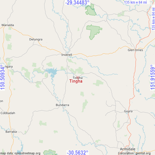
Tingha GPS coordinates[2]
29° 57' 21.168" South, 151° 12' 44.856" East
| Map corner | latitude | longitude |
|---|---|---|
| Upper-left | -29.34483°, | 150.50934° |
| Center: | -29.95588°, | 151.21246° |
| Lower-right: | -30.5632°, | 151.91559° |
| Map W x H: | 135.5×135.5 km | = 84.2×84.2mi |
| max Lat: | -10.58257° ⇑27.6% North |
| Tingha: | -29.95588° |
| min Lat: | ⇓72.4% South -43.31423° |
| min Long | Tingha | max Long |
| 113.53327° | 151.21246° | 153.61246° |
| W 73.6%⇐ | ⇒26.4% E |
Elevation
Elevation of Tingha is 786 m = 2579 ft, and this is 664 m = 2178 ft above average elevation for this country.
| Max E: |
1715 m = 5627 ft | 1.1% |
| Tingha | 786 m 2579 ft | |
| Avg. | 122 m = 400 ft | |
Min E: |
-2 m = -7 ft | 98.9% |
See also: Australia elevation on elevation.city.
Geographical zone
Tingha is located in South temperate zone (between Tropic of Capricorn and the Antarctic Circle). Distance of this Southern Tropic circle is 724.9 km =450.4 mi to North.| Distance of | km | miles | from Tingha |
|---|---|---|---|
| Equator | 3330.8 | 2069.7 | to North |
| Tropic Capricorn | 724.9 | 450.4 | to North |
| Antarctic Circle | 4070.4 | 2529.2 | to South |
| South Pole | 6676.3 | 4148.5 | to South |


Nearby cities:
15 places around Tingha: (largest is in red/bold)
• Armidale
74.6 km =46.4 mi,  144°
144°
• Ashford
71.4 km =44.4 mi,  350°
350°
• Barraba
75.1 km =46.7 mi,  230°
230°
• Bingara
62.5 km =38.8 mi,  278°
278°
• Bundarra
27.4 km =17 mi,  208°
208°
• Delungra
49.9 km =31 mi,  312°
312°
• Emmaville
68 km =42.3 mi,  33°
33°
• Gilgai
14.6 km =9.1 mi,  321°
321°
• Glen Innes
56.4 km =35 mi,  64°
64°
• Guyra
52.5 km =32.6 mi,  123°
123°
• Inverell
22.4 km =13.9 mi,  334°
334°
• Invergowrie
68 km =42.3 mi,  155°
155°
• Mitchell
92.3 km =57.4 mi,  70°
70°
• Uralla
81.1 km =50.4 mi, 160°
• Warialda
76.7 km =47.7 mi, 306°
Sources, notices
• [Note1] Compared only with cities in Australia existing in our database
• [Src1] Map data: © OpenStreetMap contributors (CC-BY-SA)
• [Src2] Other city data from geonames.org with taken over terms of usage.
• [Src3] Geographical zone / Annual Mean Temperature by Robert A. Rohde @ Wikipedia
