Glen Innes geodata
Glen Innes (New South Wales) is a populated place; located in Australia in Australia/Sydney (GMT+11) time zone. With population of 6,093 people, there are 1186 cities with bigger population in this country. Compared to other cities in Australia, 72.5% of cities are located further ↓South; 81% of cities are located further ←West and 99.8% of cities have lower elevation than Glen Innes. Note1


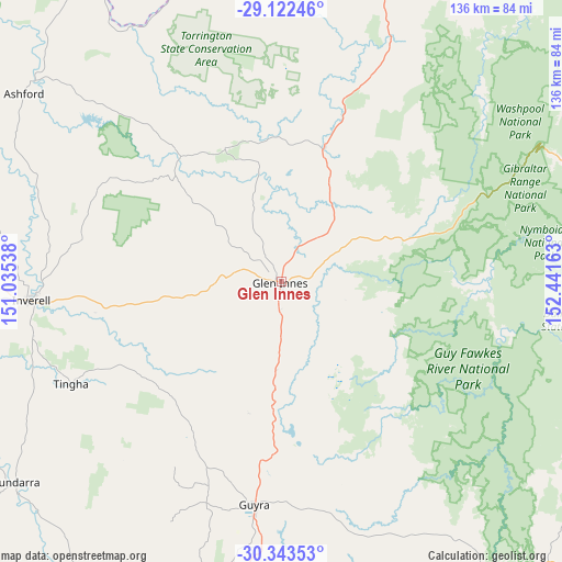
Glen Innes GPS coordinates[2]
29° 44' 5.46" South, 151° 44' 18.6" East
| Map corner | latitude | longitude |
|---|---|---|
| Upper-left | -29.12246°, | 151.03538° |
| Center: | -29.73485°, | 151.7385° |
| Lower-right: | -30.34353°, | 152.44163° |
| Map W x H: | 135.8×135.8 km | = 84.4×84.4mi |
| max Lat: | -10.58257° ⇑27.5% North |
| Glen Innes: | -29.73485° |
| min Lat: | ⇓72.5% South -43.31423° |
| min Long | Glen Innes | max Long |
| 113.53327° | 151.7385° | 153.61246° |
| W 81%⇐ | ⇒19% E |
Elevation
Elevation of Glen Innes is 1071 m = 3514 ft, and this is 949 m = 3114 ft above average elevation for this country.
| Max E: |
1715 m = 5627 ft | 0.2% |
| Glen Innes | 1071 m 3514 ft | |
| Avg. | 122 m = 400 ft | |
Min E: |
-2 m = -7 ft | 99.8% |
See also: Australia elevation on elevation.city.
Geographical zone
Glen Innes is located in South temperate zone (between Tropic of Capricorn and the Antarctic Circle). Distance of this Southern Tropic circle is 700.3 km =435.1 mi to North.| Distance of | km | miles | from Glen Innes |
|---|---|---|---|
| Equator | 3306.2 | 2054.4 | to North |
| Tropic Capricorn | 700.3 | 435.1 | to North |
| Antarctic Circle | 4095 | 2544.5 | to South |
| South Pole | 6700.9 | 4163.7 | to South |


Nearby cities:
15 places around Glen Innes: (largest is in red/bold)
• Armidale
85.5 km =53.1 mi,  184°
184°
• Ashford
77.5 km =48.2 mi,  306°
306°
• Bundarra
80.2 km =49.8 mi,  232°
232°
• Carrolls Creek
107.4 km =66.7 mi,  19°
19°
• Delungra
88.2 km =54.8 mi,  275°
275°
• Emmaville
35.1 km =21.8 mi,  337°
337°
• Gilgai
61.3 km =38.1 mi,  257°
257°
• Guyra
54 km =33.6 mi,  187°
187°
• Inverell
60.7 km =37.7 mi,  265°
265°
• Invergowrie
89.2 km =55.4 mi, 194°
• Mitchell
37 km =23 mi,  81°
81°
• Tenterfield
80.9 km =50.3 mi, 19°
• Tingha
56.4 km =35 mi,  244°
244°
• Uralla
103.3 km =64.2 mi, 192°
• Waterview Heights
106.4 km =66.1 mi,  87°
87°
Sources, notices
• [Note1] Compared only with cities in Australia existing in our database
• [Src1] Map data: © OpenStreetMap contributors (CC-BY-SA)
• [Src2] Other city data from geonames.org with taken over terms of usage.
• [Src3] Geographical zone / Annual Mean Temperature by Robert A. Rohde @ Wikipedia
