Tenterfield geodata
Tenterfield (New South Wales) is a populated place; located in Australia in Australia/Sydney (GMT+11) time zone. With population of 4,107 people, there are 1751 cities with bigger population in this country. Compared to other cities in Australia, 73.1% of cities are located further ↓South; 82.8% of cities are located further ←West and 99.1% of cities have lower elevation than Tenterfield. Note1


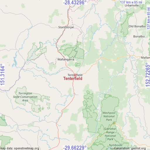
Tenterfield GPS coordinates[2]
29° 2' 58.056" South, 152° 1' 10.272" East
| Map corner | latitude | longitude |
|---|---|---|
| Upper-left | -28.43296°, | 151.3164° |
| Center: | -29.04946°, | 152.01952° |
| Lower-right: | -29.66229°, | 152.72265° |
| Map W x H: | 136.7×136.7 km | = 84.9×84.9mi |
| max Lat: | -10.58257° ⇑26.9% North |
| Tenterfield: | -29.04946° |
| min Lat: | ⇓73.1% South -43.31423° |
| min Long | Tenterfield | max Long |
| 113.53327° | 152.01952° | 153.61246° |
| W 82.8%⇐ | ⇒17.2% E |
Elevation
Elevation of Tenterfield is 849 m = 2785 ft, and this is 727 m = 2385 ft above average elevation for this country.
| Max E: |
1715 m = 5627 ft | 0.90000000000001% |
| Tenterfield | 849 m 2785 ft | |
| Avg. | 122 m = 400 ft | |
Min E: |
-2 m = -7 ft | 99.1% |
See also: Australia elevation on elevation.city.
Geographical zone
Tenterfield is located in South temperate zone (between Tropic of Capricorn and the Antarctic Circle). Distance of this Southern Tropic circle is 624.1 km =387.8 mi to North.| Distance of | km | miles | from Tenterfield |
|---|---|---|---|
| Equator | 3230 | 2007 | to North |
| Tropic Capricorn | 624.1 | 387.8 | to North |
| Antarctic Circle | 4171.2 | 2591.9 | to South |
| South Pole | 6777.1 | 4211.1 | to South |


Nearby cities:
15 places around Tenterfield: (largest is in red/bold)
• Ashford
94.9 km =59 mi,  251°
251°
• Carrolls Creek
26.5 km =16.5 mi,  17°
17°
• Casino
102.2 km =63.5 mi,  77°
77°
• Emmaville
60 km =37.3 mi,  222°
222°
• Geneva
105.7 km =65.7 mi,  63°
63°
• Glen Innes
80.9 km =50.3 mi,  199°
199°
• Junction Hill
109.7 km =68.2 mi,  126°
126°
• Killarney
84.1 km =52.3 mi, 18°
• Kyogle
106.4 km =66.1 mi, 63°
• Mitchell
71.1 km =44.2 mi,  172°
172°
• North Casino
105.5 km =65.6 mi,  74°
74°
• Rosenthal Heights
90 km =55.9 mi,  359°
359°
• Stanthorpe
44.7 km =27.8 mi,  349°
349°
• Warwick
92.3 km =57.4 mi,  0°
0°
• Waterview Heights
107.3 km =66.7 mi, 132°
Sources, notices
• [Note1] Compared only with cities in Australia existing in our database
• [Src1] Map data: © OpenStreetMap contributors (CC-BY-SA)
• [Src2] Other city data from geonames.org with taken over terms of usage.
• [Src3] Geographical zone / Annual Mean Temperature by Robert A. Rohde @ Wikipedia
