Emmaville geodata
Emmaville (New South Wales) is a populated place; located in Australia in Australia/Sydney (GMT+11) time zone. With population of 526 people, there are 4796 cities with bigger population in this country. Compared to other cities in Australia, 72.8% of cities are located further ↓South; 78.9% of cities are located further ←West and 99.2% of cities have lower elevation than Emmaville. Note1


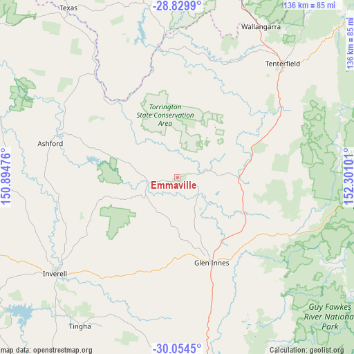
Emmaville GPS coordinates[2]
29° 26' 38.58" South, 151° 35' 52.368" East
| Map corner | latitude | longitude |
|---|---|---|
| Upper-left | -28.8299°, | 150.89476° |
| Center: | -29.44405°, | 151.59788° |
| Lower-right: | -30.0545°, | 152.30101° |
| Map W x H: | 136.2×136.2 km | = 84.6×84.6mi |
| max Lat: | -10.58257° ⇑27.2% North |
| Emmaville: | -29.44405° |
| min Lat: | ⇓72.8% South -43.31423° |
| min Long | Emmaville | max Long |
| 113.53327° | 151.59788° | 153.61246° |
| W 78.9%⇐ | ⇒21.1% E |
Elevation
Elevation of Emmaville is 885 m = 2904 ft, and this is 763 m = 2503 ft above average elevation for this country.
| Max E: |
1715 m = 5627 ft | 0.8% |
| Emmaville | 885 m 2904 ft | |
| Avg. | 122 m = 400 ft | |
Min E: |
-2 m = -7 ft | 99.2% |
See also: Australia elevation on elevation.city.
Geographical zone
Emmaville is located in South temperate zone (between Tropic of Capricorn and the Antarctic Circle). Distance of this Southern Tropic circle is 668 km =415.1 mi to North.| Distance of | km | miles | from Emmaville |
|---|---|---|---|
| Equator | 3273.9 | 2034.3 | to North |
| Tropic Capricorn | 668 | 415.1 | to North |
| Antarctic Circle | 4127.3 | 2564.6 | to South |
| South Pole | 6733.2 | 4183.8 | to South |


Nearby cities:
15 places around Emmaville: (largest is in red/bold)
• Armidale
117.7 km =73.1 mi,  176°
176°
• Ashford
50.8 km =31.6 mi,  285°
285°
• Bingara
109.8 km =68.2 mi,  244°
244°
• Bundarra
95.3 km =59.2 mi,  211°
211°
• Carrolls Creek
84.7 km =52.6 mi,  35°
35°
• Delungra
77.9 km =48.4 mi,  252°
252°
• Gilgai
64.9 km =40.3 mi,  225°
225°
• Glen Innes
35.1 km =21.8 mi,  157°
157°
• Guyra
86.2 km =53.6 mi, 175°
• Inverell
59.6 km =37 mi, 232°
• Mitchell
56.8 km =35.3 mi,  117°
117°
• Stanthorpe
93.7 km =58.2 mi,  20°
20°
• Tenterfield
60 km =37.3 mi, 42°
• Tingha
68 km =42.3 mi, 213°
• Warialda
99.6 km =61.9 mi,  263°
263°
Sources, notices
• [Note1] Compared only with cities in Australia existing in our database
• [Src1] Map data: © OpenStreetMap contributors (CC-BY-SA)
• [Src2] Other city data from geonames.org with taken over terms of usage.
• [Src3] Geographical zone / Annual Mean Temperature by Robert A. Rohde @ Wikipedia
