Maryborough geodata
Maryborough (Victoria) is a populated place; located in Australia in Australia/Melbourne (GMT+11) time zone. With population of 7,830 people, there are 858 cities with bigger population in this country. Compared to other cities in Australia, 81.6% of cities are located further ↑North; 73.4% of cities are located further →East and 84.6% of cities have lower elevation than Maryborough. Note1


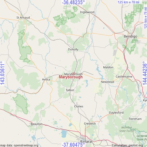
Maryborough GPS coordinates[2]
37° 2' 44.232" South, 143° 44' 21.228" East
| Map corner | latitude | longitude |
|---|---|---|
| Upper-left | -36.48235°, | 143.03611° |
| Center: | -37.04562°, | 143.73923° |
| Lower-right: | -37.60475°, | 144.44236° |
| Map W x H: | 124.8×124.8 km | = 77.5×77.5mi |
| max Lat: | -10.58257° ⇑81.6% North |
| Maryborough: | -37.04562° |
| min Lat: | ⇓18.4% South -43.31423° |
| min Long | Maryborough | max Long |
| 113.53327° | 143.73923° | 153.61246° |
| W 26.6%⇐ | ⇒73.4% E |
Elevation
Elevation of Maryborough is 241 m = 791 ft, and this is 119 m = 390 ft above average elevation for this country.
| Max E: |
1715 m = 5627 ft | 15.4% |
| Maryborough | 241 m 791 ft | |
| Avg. | 122 m = 400 ft | |
Min E: |
-2 m = -7 ft | 84.6% |
See also: Australia elevation on elevation.city.
Geographical zone
Maryborough is located in South temperate zone (between Tropic of Capricorn and the Antarctic Circle). Distance of this Southern Tropic circle is 1513.2 km =940.3 mi to North.| Distance of | km | miles | from Maryborough |
|---|---|---|---|
| Equator | 4119.1 | 2559.5 | to North |
| Tropic Capricorn | 1513.2 | 940.3 | to North |
| Antarctic Circle | 3282.1 | 2039.4 | to South |
| South Pole | 5888 | 3658.6 | to South |


Nearby cities:
15 places around Maryborough: (largest is in red/bold)
• Avoca
24.1 km =15 mi,  258°
258°
• Campbells Creek
41.3 km =25.7 mi,  96°
96°
• Carisbrook
6.9 km =4.3 mi,  92°
92°
• Castlemaine
42.4 km =26.3 mi, 93°
• Chewton
46.1 km =28.6 mi, 94°
• Clunes
28 km =17.4 mi,  171°
171°
• Creswick
44.3 km =27.5 mi,  161°
161°
• Daylesford
48.5 km =30.1 mi,  132°
132°
• Dunolly
20.6 km =12.8 mi,  358°
358°
• Harcourt
46.5 km =28.9 mi,  83°
83°
• Hepburn
46.1 km =28.6 mi, 130°
• Lockwood
45.4 km =28.2 mi,  54°
54°
• Lockwood South
43.5 km =27 mi,  58°
58°
• Maldon
29.7 km =18.5 mi, 79°
• Newstead
29.6 km =18.4 mi, 103°
Sources, notices
• [Note1] Compared only with cities in Australia existing in our database
• [Src1] Map data: © OpenStreetMap contributors (CC-BY-SA)
• [Src2] Other city data from geonames.org with taken over terms of usage.
• [Src3] Geographical zone / Annual Mean Temperature by Robert A. Rohde @ Wikipedia
