Trentham geodata
Trentham (Victoria) is a populated place; located in Australia in Australia/Melbourne (GMT+11) time zone. With population of 1,110 people, there are 3687 cities with bigger population in this country. Compared to other cities in Australia, 82.3% of cities are located further ↑North; 71.2% of cities are located further →East and 98.4% of cities have lower elevation than Trentham. Note1


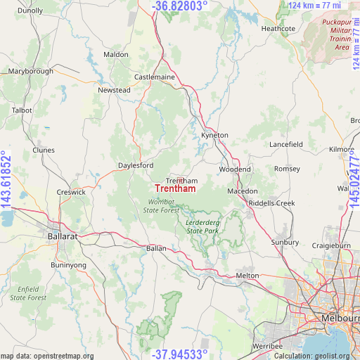
Trentham GPS coordinates[2]
37° 23' 19.536" South, 144° 19' 17.904" East
| Map corner | latitude | longitude |
|---|---|---|
| Upper-left | -36.82803°, | 143.61852° |
| Center: | -37.38876°, | 144.32164° |
| Lower-right: | -37.94533°, | 145.02477° |
| Map W x H: | 124.2×124.2 km | = 77.2×77.2mi |
| max Lat: | -10.58257° ⇑82.3% North |
| Trentham: | -37.38876° |
| min Lat: | ⇓17.7% South -43.31423° |
| min Long | Trentham | max Long |
| 113.53327° | 144.32164° | 153.61246° |
| W 28.8%⇐ | ⇒71.2% E |
Elevation
Elevation of Trentham is 703 m = 2306 ft, and this is 581 m = 1906 ft above average elevation for this country.
| Max E: |
1715 m = 5627 ft | 1.6% |
| Trentham | 703 m 2306 ft | |
| Avg. | 122 m = 400 ft | |
Min E: |
-2 m = -7 ft | 98.4% |
See also: Australia elevation on elevation.city.
Geographical zone
Trentham is located in South temperate zone (between Tropic of Capricorn and the Antarctic Circle). Distance of this Southern Tropic circle is 1551.3 km =963.9 mi to North.| Distance of | km | miles | from Trentham |
|---|---|---|---|
| Equator | 4157.2 | 2583.2 | to North |
| Tropic Capricorn | 1551.3 | 963.9 | to North |
| Antarctic Circle | 3243.9 | 2015.7 | to South |
| South Pole | 5849.8 | 3634.9 | to South |


Nearby cities:
15 places around Trentham: (largest is in red/bold)
• Ballan
24.9 km =15.5 mi,  199°
199°
• Bullengarook
20.1 km =12.5 mi,  134°
134°
• Daylesford
16.7 km =10.4 mi,  288°
288°
• Gisborne
26.5 km =16.5 mi,  114°
114°
• Gisborne South
30.2 km =18.8 mi,  124°
124°
• Gordon
28.5 km =17.7 mi,  221°
221°
• Greendale
19.2 km =11.9 mi,  186°
186°
• Hepburn
18.5 km =11.5 mi,  295°
295°
• Kyneton
19.7 km =12.2 mi,  35°
35°
• Macedon
21.5 km =13.4 mi,  99°
99°
• Malmsbury
22.9 km =14.2 mi,  14°
14°
• Mount Macedon
23.2 km =14.4 mi,  93°
93°
• New Gisborne
25.8 km =16 mi, 108°
• Tylden
10.2 km =6.3 mi,  46°
46°
• Woodend
18.7 km =11.6 mi,  78°
78°
Sources, notices
• [Note1] Compared only with cities in Australia existing in our database
• [Src1] Map data: © OpenStreetMap contributors (CC-BY-SA)
• [Src2] Other city data from geonames.org with taken over terms of usage.
• [Src3] Geographical zone / Annual Mean Temperature by Robert A. Rohde @ Wikipedia
