Grantville geodata
Grantville (Victoria) is a populated place; located in Australia in Australia/Melbourne (GMT+11) time zone. With population of 813 people, there are 4117 cities with bigger population in this country. Compared to other cities in Australia, 95.6% of cities are located further ↑North; 59.5% of cities are located further →East and 85% of cities have higher elevation than Grantville. Note1


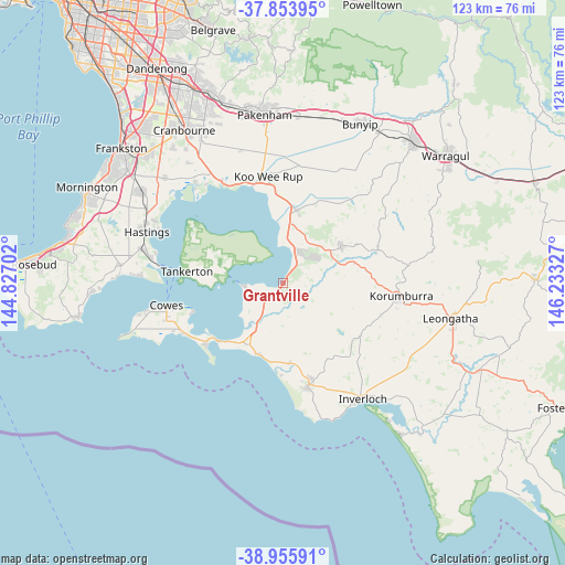
Grantville GPS coordinates[2]
38° 24' 25.308" South, 145° 31' 48.504" East
| Map corner | latitude | longitude |
|---|---|---|
| Upper-left | -37.85395°, | 144.82702° |
| Center: | -38.40703°, | 145.53014° |
| Lower-right: | -38.95591°, | 146.23327° |
| Map W x H: | 122.5×122.5 km | = 76.1×76.1mi |
| max Lat: | -10.58257° ⇑95.6% North |
| Grantville: | -38.40703° |
| min Lat: | ⇓4.4% South -43.31423° |
| min Long | Grantville | max Long |
| 113.53327° | 145.53014° | 153.61246° |
| W 40.5%⇐ | ⇒59.5% E |
Elevation
Elevation of Grantville is 12 m = 39 ft, and this is 110 m = 361 ft below average elevation for this country.
| Max E: |
1715 m = 5627 ft | 85% |
| Avg. | 122 m = 400 ft | |
| Grantville | 12 m = 39 ft | |
Min E: |
-2 m = -7 ft | 15% |
See also: Australia elevation on elevation.city.
Geographical zone
Grantville is located in South temperate zone (between Tropic of Capricorn and the Antarctic Circle). Distance of this Southern Tropic circle is 1664.5 km =1034.3 mi to North.| Distance of | km | miles | from Grantville |
|---|---|---|---|
| Equator | 4270.5 | 2653.6 | to North |
| Tropic Capricorn | 1664.5 | 1034.3 | to North |
| Antarctic Circle | 3130.7 | 1945.3 | to South |
| South Pole | 5736.6 | 3564.6 | to South |


Nearby cities:
15 places around Grantville: (largest is in red/bold)
• Cape Woolamai
22.1 km =13.7 mi,  227°
227°
• Corinella
9 km =5.6 mi,  264°
264°
• Coronet Bay
8.2 km =5.1 mi,  244°
244°
• Dalyston
17.8 km =11.1 mi,  174°
174°
• Koo-Wee-Rup
23.3 km =14.5 mi,  351°
351°
• Korumburra
25.7 km =16 mi,  96°
96°
• Lang Lang
15.9 km =9.9 mi,  10°
10°
• Loch
16.1 km =10 mi,  74°
74°
• North Wonthaggi
19.7 km =12.2 mi,  163°
163°
• Nyora
14.9 km =9.3 mi,  56°
56°
• Poowong
21.6 km =13.4 mi, 70°
• Rhyll
21.1 km =13.1 mi,  252°
252°
• San Remo
18.8 km =11.7 mi, 225°
• Tooradin
24.9 km =15.5 mi,  329°
329°
• Wonthaggi
22.8 km =14.2 mi, 165°
Sources, notices
• [Note1] Compared only with cities in Australia existing in our database
• [Src1] Map data: © OpenStreetMap contributors (CC-BY-SA)
• [Src2] Other city data from geonames.org with taken over terms of usage.
• [Src3] Geographical zone / Annual Mean Temperature by Robert A. Rohde @ Wikipedia
