Coronet Bay geodata
Coronet Bay (Victoria) is a populated place; located in Australia in Australia/Melbourne (GMT+11) time zone. With population of 774 people, there are 4196 cities with bigger population in this country. Compared to other cities in Australia, 95.7% of cities are located further ↑North; 60% of cities are located further →East and 56.9% of cities have higher elevation than Coronet Bay. Note1


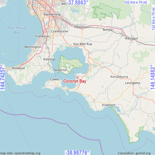
Coronet Bay GPS coordinates[2]
38° 26' 20.868" South, 145° 26' 44.484" East
| Map corner | latitude | longitude |
|---|---|---|
| Upper-left | -37.8863°, | 144.74257° |
| Center: | -38.43913°, | 145.44569° |
| Lower-right: | -38.98776°, | 146.14882° |
| Map W x H: | 122.5×122.5 km | = 76.1×76.1mi |
| max Lat: | -10.58257° ⇑95.7% North |
| Coronet Bay: | -38.43913° |
| min Lat: | ⇓4.3% South -43.31423° |
| min Long | Coronet Bay | max Long |
| 113.53327° | 145.44569° | 153.61246° |
| W 40%⇐ | ⇒60% E |
Elevation
Elevation of Coronet Bay is 36 m = 118 ft, and this is 86 m = 282 ft below average elevation for this country.
| Max E: |
1715 m = 5627 ft | 56.9% |
| Avg. | 122 m = 400 ft | |
| Coronet Bay | 36 m = 118 ft | |
Min E: |
-2 m = -7 ft | 43.1% |
See also: Australia elevation on elevation.city.
Geographical zone
Coronet Bay is located in South temperate zone (between Tropic of Capricorn and the Antarctic Circle). Distance of this Southern Tropic circle is 1668.1 km =1036.5 mi to North.| Distance of | km | miles | from Coronet Bay |
|---|---|---|---|
| Equator | 4274 | 2655.7 | to North |
| Tropic Capricorn | 1668.1 | 1036.5 | to North |
| Antarctic Circle | 3127.1 | 1943.1 | to South |
| South Pole | 5733 | 3562.3 | to South |


Nearby cities:
15 places around Coronet Bay: (largest is in red/bold)
• Cape Woolamai
14.5 km =9 mi,  217°
217°
• Corinella
3.2 km =2 mi,  330°
330°
• Cowes
18.1 km =11.2 mi,  265°
265°
• Crib Point
23.6 km =14.7 mi,  294°
294°
• Dalyston
16.8 km =10.4 mi,  147°
147°
• Grantville
8.2 km =5.1 mi,  64°
64°
• Hmas Cerberus
22.9 km =14.2 mi, 291°
• Lang Lang
21.8 km =13.5 mi,  27°
27°
• North Wonthaggi
20 km =12.4 mi,  140°
140°
• Nyora
23 km =14.3 mi, 59°
• Phillip Island
19.3 km =12 mi,  255°
255°
• Rhyll
13 km =8.1 mi, 257°
• San Remo
11.3 km =7 mi,  212°
212°
• Ventnor
22 km =13.7 mi, 263°
• Wonthaggi
22.6 km =14 mi, 145°
Sources, notices
• [Note1] Compared only with cities in Australia existing in our database
• [Src1] Map data: © OpenStreetMap contributors (CC-BY-SA)
• [Src2] Other city data from geonames.org with taken over terms of usage.
• [Src3] Geographical zone / Annual Mean Temperature by Robert A. Rohde @ Wikipedia
