North Wonthaggi geodata
North Wonthaggi (Victoria) is a populated place; located in Australia in Australia/Melbourne (GMT+11) time zone. With population of 2,746 people, there are 2416 cities with bigger population in this country. Compared to other cities in Australia, 96.1% of cities are located further ↑North; 59.1% of cities are located further →East and 55.2% of cities have higher elevation than North Wonthaggi. Note1


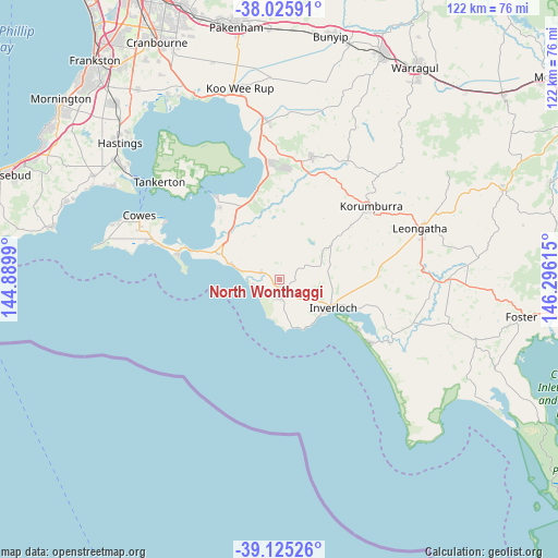
North Wonthaggi GPS coordinates[2]
38° 34' 39.684" South, 145° 35' 34.872" East
| Map corner | latitude | longitude |
|---|---|---|
| Upper-left | -38.02591°, | 144.8899° |
| Center: | -38.57769°, | 145.59302° |
| Lower-right: | -39.12526°, | 146.29615° |
| Map W x H: | 122.2×122.2 km | = 75.9×75.9mi |
| max Lat: | -10.58257° ⇑96.1% North |
| North Wonthaggi: | -38.57769° |
| min Lat: | ⇓3.9% South -43.31423° |
| min Long | North Wonthaggi | max Long |
| 113.53327° | 145.59302° | 153.61246° |
| W 40.9%⇐ | ⇒59.1% E |
Elevation
Elevation of North Wonthaggi is 38 m = 125 ft, and this is 84 m = 276 ft below average elevation for this country.
| Max E: |
1715 m = 5627 ft | 55.2% |
| Avg. | 122 m = 400 ft | |
| North Wonthaggi | 38 m = 125 ft | |
Min E: |
-2 m = -7 ft | 44.8% |
See also: Australia elevation on elevation.city.
Geographical zone
North Wonthaggi is located in South temperate zone (between Tropic of Capricorn and the Antarctic Circle). Distance of this Southern Tropic circle is 1683.5 km =1046.1 mi to North.| Distance of | km | miles | from North Wonthaggi |
|---|---|---|---|
| Equator | 4289.4 | 2665.3 | to North |
| Tropic Capricorn | 1683.5 | 1046.1 | to North |
| Antarctic Circle | 3111.7 | 1933.5 | to South |
| South Pole | 5717.6 | 3552.8 | to South |


Nearby cities:
15 places around North Wonthaggi: (largest is in red/bold)
• Cape Paterson
10.6 km =6.6 mi,  166°
166°
• Cape Woolamai
22 km =13.7 mi,  280°
280°
• Corinella
23.2 km =14.4 mi,  321°
321°
• Coronet Bay
20 km =12.4 mi, 320°
• Dalyston
3.9 km =2.4 mi,  288°
288°
• Grantville
19.7 km =12.2 mi,  343°
343°
• Inverloch
12.5 km =7.8 mi,  115°
115°
• Korumburra
25.8 km =16 mi,  51°
51°
• Loch
25.3 km =15.7 mi,  23°
23°
• Nyora
28 km =17.4 mi,  14°
14°
• Poowong
30 km =18.6 mi,  29°
29°
• Rhyll
28.5 km =17.7 mi,  296°
296°
• San Remo
19.7 km =12.2 mi, 287°
• Venus Bay
24.1 km =15 mi, 124°
• Wonthaggi
3.1 km =1.9 mi,  179°
179°
Sources, notices
• [Note1] Compared only with cities in Australia existing in our database
• [Src1] Map data: © OpenStreetMap contributors (CC-BY-SA)
• [Src2] Other city data from geonames.org with taken over terms of usage.
• [Src3] Geographical zone / Annual Mean Temperature by Robert A. Rohde @ Wikipedia
