Poowong geodata
Poowong (Victoria) is a populated place; located in Australia in Australia/Melbourne (GMT+11) time zone. With population of 620 people, there are 4515 cities with bigger population in this country. Compared to other cities in Australia, 95.1% of cities are located further ↑North; 58% of cities are located further →East and 81.2% of cities have lower elevation than Poowong. Note1


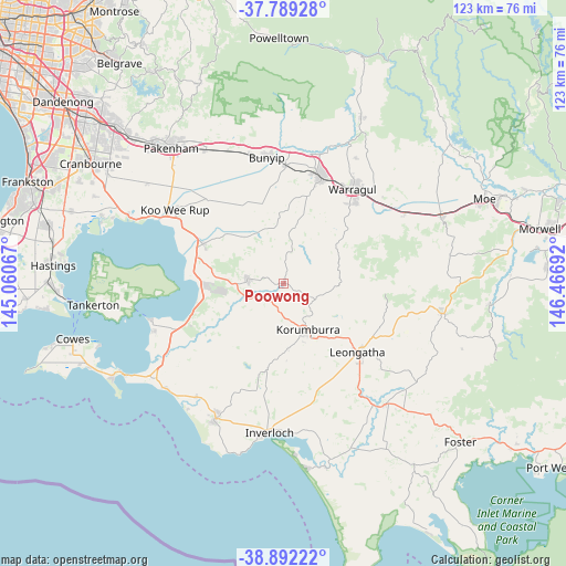
Poowong GPS coordinates[2]
38° 20' 34.26" South, 145° 45' 49.644" East
| Map corner | latitude | longitude |
|---|---|---|
| Upper-left | -37.78928°, | 145.06067° |
| Center: | -38.34285°, | 145.76379° |
| Lower-right: | -38.89222°, | 146.46692° |
| Map W x H: | 122.6×122.6 km | = 76.2×76.2mi |
| max Lat: | -10.58257° ⇑95.1% North |
| Poowong: | -38.34285° |
| min Lat: | ⇓4.9% South -43.31423° |
| min Long | Poowong | max Long |
| 113.53327° | 145.76379° | 153.61246° |
| W 42%⇐ | ⇒58% E |
Elevation
Elevation of Poowong is 194 m = 636 ft, and this is 72 m = 236 ft above average elevation for this country.
| Max E: |
1715 m = 5627 ft | 18.8% |
| Poowong | 194 m 636 ft | |
| Avg. | 122 m = 400 ft | |
Min E: |
-2 m = -7 ft | 81.2% |
See also: Australia elevation on elevation.city.
Geographical zone
Poowong is located in South temperate zone (between Tropic of Capricorn and the Antarctic Circle). Distance of this Southern Tropic circle is 1657.4 km =1029.9 mi to North.| Distance of | km | miles | from Poowong |
|---|---|---|---|
| Equator | 4263.3 | 2649.1 | to North |
| Tropic Capricorn | 1657.4 | 1029.9 | to North |
| Antarctic Circle | 3137.8 | 1949.7 | to South |
| South Pole | 5743.7 | 3569 | to South |


Nearby cities:
15 places around Poowong: (largest is in red/bold)
• Bunyip
27.6 km =17.1 mi,  351°
351°
• Coronet Bay
29.7 km =18.5 mi,  248°
248°
• Darnum
27.2 km =16.9 mi,  50°
50°
• Drouin
24.4 km =15.2 mi,  19°
19°
• Garfield
29.2 km =18.1 mi,  344°
344°
• Grantville
21.6 km =13.4 mi, 250°
• Koo-Wee-Rup
28.7 km =17.8 mi,  303°
303°
• Korumburra
11.2 km =7 mi,  152°
152°
• Lang Lang
19.6 km =12.2 mi, 295°
• Leongatha
21.8 km =13.5 mi,  132°
132°
• Loch
5.7 km =3.5 mi,  238°
238°
• Longwarry
25.6 km =15.9 mi,  0°
0°
• North Wonthaggi
30 km =18.6 mi,  209°
209°
• Nyora
8 km =5 mi,  277°
277°
• Warragul
25.1 km =15.6 mi,  35°
35°
Sources, notices
• [Note1] Compared only with cities in Australia existing in our database
• [Src1] Map data: © OpenStreetMap contributors (CC-BY-SA)
• [Src2] Other city data from geonames.org with taken over terms of usage.
• [Src3] Geographical zone / Annual Mean Temperature by Robert A. Rohde @ Wikipedia
