Yea geodata
Yea (Victoria) is a populated place; located in Australia in Australia/Melbourne (GMT+11) time zone. With population of 1,553 people, there are 3236 cities with bigger population in this country. Compared to other cities in Australia, 82% of cities are located further ↑North; 60.2% of cities are located further →East and 79.2% of cities have lower elevation than Yea. Note1


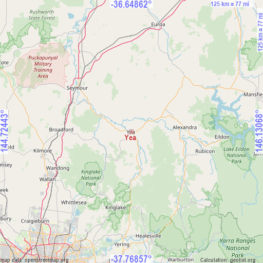
Yea GPS coordinates[2]
37° 12' 38.412" South, 145° 25' 39.18" East
| Map corner | latitude | longitude |
|---|---|---|
| Upper-left | -36.64862°, | 144.72443° |
| Center: | -37.21067°, | 145.42755° |
| Lower-right: | -37.76857°, | 146.13068° |
| Map W x H: | 124.5×124.5 km | = 77.4×77.4mi |
| max Lat: | -10.58257° ⇑82% North |
| Yea: | -37.21067° |
| min Lat: | ⇓18% South -43.31423° |
| min Long | Yea | max Long |
| 113.53327° | 145.42755° | 153.61246° |
| W 39.8%⇐ | ⇒60.2% E |
Elevation
Elevation of Yea is 170 m = 558 ft, and this is 48 m = 157 ft above average elevation for this country.
| Max E: |
1715 m = 5627 ft | 20.8% |
| Yea | 170 m 558 ft | |
| Avg. | 122 m = 400 ft | |
Min E: |
-2 m = -7 ft | 79.2% |
See also: Australia elevation on elevation.city.
Geographical zone
Yea is located in South temperate zone (between Tropic of Capricorn and the Antarctic Circle). Distance of this Southern Tropic circle is 1531.5 km =951.6 mi to North.| Distance of | km | miles | from Yea |
|---|---|---|---|
| Equator | 4137.4 | 2570.9 | to North |
| Tropic Capricorn | 1531.5 | 951.6 | to North |
| Antarctic Circle | 3263.7 | 2028 | to South |
| South Pole | 5869.6 | 3647.2 | to South |


Nearby cities:
15 places around Yea: (largest is in red/bold)
• Alexandra
25.2 km =15.7 mi,  85°
85°
• Avenel
38.5 km =23.9 mi,  333°
333°
• Broadford
33.6 km =20.9 mi,  271°
271°
• Chum Creek
44.2 km =27.5 mi,  173°
173°
• Eden Park
43 km =26.7 mi,  225°
225°
• Eildon
43 km =26.7 mi, 93°
• Flowerdale
16 km =9.9 mi,  211°
211°
• Kilmore
43.1 km =26.8 mi,  257°
257°
• Kinglake
36.7 km =22.8 mi,  192°
192°
• Kinglake West
33.2 km =20.6 mi, 211°
• Puckapunyal
41.9 km =26 mi,  304°
304°
• Seymour
32.7 km =20.3 mi,  308°
308°
• Tallarook
31.8 km =19.8 mi,  294°
294°
• Wandong
39.3 km =24.4 mi,  242°
242°
• Whittlesea
43.2 km =26.8 mi,  219°
219°
Sources, notices
• [Note1] Compared only with cities in Australia existing in our database
• [Src1] Map data: © OpenStreetMap contributors (CC-BY-SA)
• [Src2] Other city data from geonames.org with taken over terms of usage.
• [Src3] Geographical zone / Annual Mean Temperature by Robert A. Rohde @ Wikipedia
