Cohuna geodata
Cohuna (Victoria) is a populated place; located in Australia in Australia/Melbourne (GMT+11) time zone. With population of 2,336 people, there are 2666 cities with bigger population in this country. Compared to other cities in Australia, 77.9% of cities are located further ↑North; 71.9% of cities are located further →East and 66.6% of cities have lower elevation than Cohuna. Note1


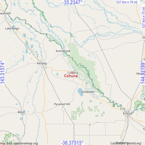
Cohuna GPS coordinates[2]
35° 48' 25.092" South, 144° 13' 7.896" East
| Map corner | latitude | longitude |
|---|---|---|
| Upper-left | -35.2347°, | 143.51574° |
| Center: | -35.80697°, | 144.21886° |
| Lower-right: | -36.37515°, | 144.92199° |
| Map W x H: | 126.8×126.8 km | = 78.8×78.8mi |
| max Lat: | -10.58257° ⇑77.9% North |
| Cohuna: | -35.80697° |
| min Lat: | ⇓22.1% South -43.31423° |
| min Long | Cohuna | max Long |
| 113.53327° | 144.21886° | 153.61246° |
| W 28.1%⇐ | ⇒71.9% E |
Elevation
Elevation of Cohuna is 86 m = 282 ft, and this is 36 m = 118 ft below average elevation for this country.
| Max E: |
1715 m = 5627 ft | 33.4% |
| Avg. | 122 m = 400 ft | |
| Cohuna | 86 m = 282 ft | |
Min E: |
-2 m = -7 ft | 66.6% |
See also: Australia elevation on elevation.city.
Geographical zone
Cohuna is located in South temperate zone (between Tropic of Capricorn and the Antarctic Circle). Distance of this Southern Tropic circle is 1375.4 km =854.6 mi to North.| Distance of | km | miles | from Cohuna |
|---|---|---|---|
| Equator | 3981.4 | 2473.9 | to North |
| Tropic Capricorn | 1375.4 | 854.6 | to North |
| Antarctic Circle | 3419.8 | 2125 | to South |
| South Pole | 6025.7 | 3744.2 | to South |


Nearby cities:
15 places around Cohuna: (largest is in red/bold)
• Barham
21.6 km =13.4 mi,  337°
337°
• Boort
56.5 km =35.1 mi,  232°
232°
• Deniliquin
73.1 km =45.4 mi,  65°
65°
• Echuca
60.6 km =37.7 mi,  127°
127°
• Echuca Village
64.9 km =40.3 mi,  124°
124°
• Gunbower
21.4 km =13.3 mi,  140°
140°
• Kerang
28.1 km =17.5 mi,  286°
286°
• Koondrook
21.2 km =13.2 mi, 336°
• Lake Boga
65.3 km =40.6 mi,  305°
305°
• Leitchville
13.1 km =8.1 mi,  145°
145°
• Lockington
59 km =36.7 mi, 150°
• Mathoura
61.5 km =38.2 mi,  90°
90°
• Moama
58.9 km =36.6 mi, 124°
• Pyramid Hill
29.2 km =18.1 mi,  198°
198°
• Rochester
75.5 km =46.9 mi, 145°
Sources, notices
• [Note1] Compared only with cities in Australia existing in our database
• [Src1] Map data: © OpenStreetMap contributors (CC-BY-SA)
• [Src2] Other city data from geonames.org with taken over terms of usage.
• [Src3] Geographical zone / Annual Mean Temperature by Robert A. Rohde @ Wikipedia
