Barham geodata
Barham (New South Wales) is a populated place; located in Australia in Australia/Sydney (GMT+11) time zone. With population of 1,534 people, there are 3255 cities with bigger population in this country. Compared to other cities in Australia, 77.4% of cities are located further ↑North; 72.2% of cities are located further →East and 64.9% of cities have lower elevation than Barham. Note1


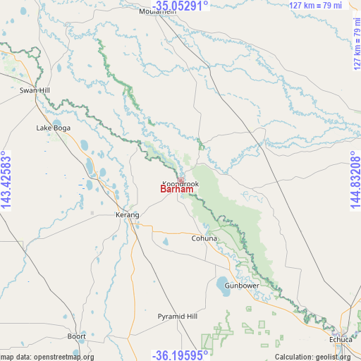
Barham GPS coordinates[2]
35° 37' 35.292" South, 144° 7' 44.22" East
| Map corner | latitude | longitude |
|---|---|---|
| Upper-left | -35.05291°, | 143.42583° |
| Center: | -35.62647°, | 144.12895° |
| Lower-right: | -36.19595°, | 144.83208° |
| Map W x H: | 127.1×127.1 km | = 79×79mi |
| max Lat: | -10.58257° ⇑77.4% North |
| Barham: | -35.62647° |
| min Lat: | ⇓22.6% South -43.31423° |
| min Long | Barham | max Long |
| 113.53327° | 144.12895° | 153.61246° |
| W 27.8%⇐ | ⇒72.2% E |
Elevation
Elevation of Barham is 80 m = 262 ft, and this is 42 m = 138 ft below average elevation for this country.
| Max E: |
1715 m = 5627 ft | 35.1% |
| Avg. | 122 m = 400 ft | |
| Barham | 80 m = 262 ft | |
Min E: |
-2 m = -7 ft | 64.9% |
See also: Australia elevation on elevation.city.
Geographical zone
Barham is located in South temperate zone (between Tropic of Capricorn and the Antarctic Circle). Distance of this Southern Tropic circle is 1355.4 km =842.2 mi to North.| Distance of | km | miles | from Barham |
|---|---|---|---|
| Equator | 3961.3 | 2461.4 | to North |
| Tropic Capricorn | 1355.4 | 842.2 | to North |
| Antarctic Circle | 3439.9 | 2137.5 | to South |
| South Pole | 6045.8 | 3756.7 | to South |


Nearby cities:
15 places around Barham: (largest is in red/bold)
• Boort
65.7 km =40.8 mi,  214°
214°
• Cohuna
21.6 km =13.4 mi,  157°
157°
• Deniliquin
75.3 km =46.8 mi,  82°
82°
• Echuca
80.1 km =49.8 mi,  135°
135°
• Echuca Village
83.8 km =52.1 mi,  132°
132°
• Gunbower
42.6 km =26.5 mi,  149°
149°
• Kerang
22.4 km =13.9 mi,  237°
237°
• Koondrook
0.7 km =0.4 mi, 212°
• Lake Boga
48.4 km =30.1 mi,  292°
292°
• Leitchville
34.6 km =21.5 mi, 153°
• Lockington
80.6 km =50.1 mi, 152°
• Mathoura
72.8 km =45.2 mi,  106°
106°
• Moama
77.9 km =48.4 mi, 133°
• Pyramid Hill
47.8 km =29.7 mi,  181°
181°
• Swan Hill
61.1 km =38 mi,  301°
301°
Sources, notices
• [Note1] Compared only with cities in Australia existing in our database
• [Src1] Map data: © OpenStreetMap contributors (CC-BY-SA)
• [Src2] Other city data from geonames.org with taken over terms of usage.
• [Src3] Geographical zone / Annual Mean Temperature by Robert A. Rohde @ Wikipedia
