Kerang geodata
Kerang (Victoria) is a populated place; located in Australia in Australia/Melbourne (GMT+11) time zone. With population of 3,837 people, there are 1853 cities with bigger population in this country. Compared to other cities in Australia, 77.7% of cities are located further ↑North; 72.5% of cities are located further →East and 66.6% of cities have lower elevation than Kerang. Note1


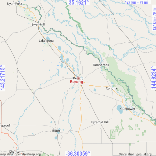
Kerang GPS coordinates[2]
35° 44' 5.604" South, 143° 55' 12.972" East
| Map corner | latitude | longitude |
|---|---|---|
| Upper-left | -35.1621°, | 143.21715° |
| Center: | -35.73489°, | 143.92027° |
| Lower-right: | -36.30359°, | 144.6234° |
| Map W x H: | 126.9×126.9 km | = 78.9×78.9mi |
| max Lat: | -10.58257° ⇑77.7% North |
| Kerang: | -35.73489° |
| min Lat: | ⇓22.3% South -43.31423° |
| min Long | Kerang | max Long |
| 113.53327° | 143.92027° | 153.61246° |
| W 27.5%⇐ | ⇒72.5% E |
Elevation
Elevation of Kerang is 86 m = 282 ft, and this is 36 m = 118 ft below average elevation for this country.
| Max E: |
1715 m = 5627 ft | 33.4% |
| Avg. | 122 m = 400 ft | |
| Kerang | 86 m = 282 ft | |
Min E: |
-2 m = -7 ft | 66.6% |
See also: Australia elevation on elevation.city.
Geographical zone
Kerang is located in South temperate zone (between Tropic of Capricorn and the Antarctic Circle). Distance of this Southern Tropic circle is 1367.4 km =849.7 mi to North.| Distance of | km | miles | from Kerang |
|---|---|---|---|
| Equator | 3973.3 | 2468.9 | to North |
| Tropic Capricorn | 1367.4 | 849.7 | to North |
| Antarctic Circle | 3427.8 | 2129.9 | to South |
| South Pole | 6033.7 | 3749.2 | to South |


Nearby cities:
15 places around Kerang: (largest is in red/bold)
• Barham
22.4 km =13.9 mi,  57°
57°
• Boort
46 km =28.6 mi,  203°
203°
• Charlton
78.1 km =48.5 mi,  221°
221°
• Cohuna
28.1 km =17.5 mi,  106°
106°
• Gunbower
47.4 km =29.5 mi,  121°
121°
• Koondrook
21.7 km =13.5 mi, 58°
• Lake Boga
39.9 km =24.8 mi,  319°
319°
• Leitchville
39.2 km =24.4 mi, 118°
• Lockington
81.5 km =50.6 mi,  137°
137°
• Nyah
79.3 km =49.3 mi, 321°
• Nyah West
80 km =49.7 mi, 319°
• Pyramid Hill
39.7 km =24.7 mi,  153°
153°
• Swan Hill
55.2 km =34.3 mi, 323°
• Wedderburn
80.9 km =50.3 mi, 199°
• Wycheproof
73.1 km =45.4 mi,  238°
238°
Sources, notices
• [Note1] Compared only with cities in Australia existing in our database
• [Src1] Map data: © OpenStreetMap contributors (CC-BY-SA)
• [Src2] Other city data from geonames.org with taken over terms of usage.
• [Src3] Geographical zone / Annual Mean Temperature by Robert A. Rohde @ Wikipedia
