Grenfell geodata
Grenfell (New South Wales) is a populated place; located in Australia in Australia/Sydney (GMT+11) time zone. With population of 2,488 people, there are 2582 cities with bigger population in this country. Compared to other cities in Australia, 55.8% of cities are located further ↑North; 51.2% of cities are located further ←West and 90.4% of cities have lower elevation than Grenfell. Note1


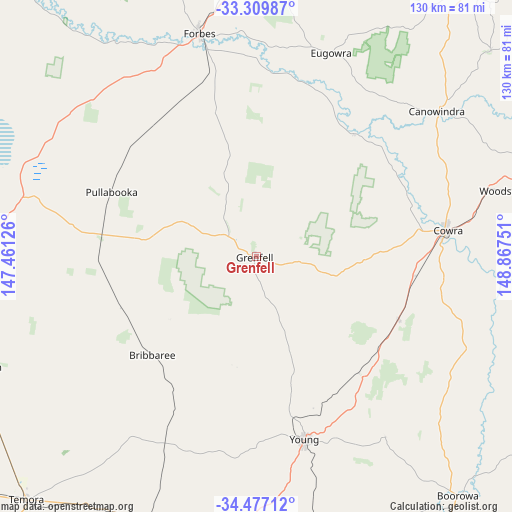
Grenfell GPS coordinates[2]
33° 53' 43.764" South, 148° 9' 51.768" East
| Map corner | latitude | longitude |
|---|---|---|
| Upper-left | -33.30987°, | 147.46126° |
| Center: | -33.89549°, | 148.16438° |
| Lower-right: | -34.47712°, | 148.86751° |
| Map W x H: | 129.8×129.8 km | = 80.7×80.7mi |
| max Lat: | -10.58257° ⇑55.8% North |
| Grenfell: | -33.89549° |
| min Lat: | ⇓44.2% South -43.31423° |
| min Long | Grenfell | max Long |
| 113.53327° | 148.16438° | 153.61246° |
| W 51.2%⇐ | ⇒48.8% E |
Elevation
Elevation of Grenfell is 389 m = 1276 ft, and this is 267 m = 876 ft above average elevation for this country.
| Max E: |
1715 m = 5627 ft | 9.6% |
| Grenfell | 389 m 1276 ft | |
| Avg. | 122 m = 400 ft | |
Min E: |
-2 m = -7 ft | 90.4% |
See also: Australia elevation on elevation.city.
Geographical zone
Grenfell is located in South temperate zone (between Tropic of Capricorn and the Antarctic Circle). Distance of this Southern Tropic circle is 1162.9 km =722.6 mi to North.| Distance of | km | miles | from Grenfell |
|---|---|---|---|
| Equator | 3768.8 | 2341.8 | to North |
| Tropic Capricorn | 1162.9 | 722.6 | to North |
| Antarctic Circle | 3632.3 | 2257 | to South |
| South Pole | 6238.2 | 3876.2 | to South |


Nearby cities:
15 places around Grenfell: (largest is in red/bold)
• Boorowa
78.7 km =48.9 mi,  139°
139°
• Canowindra
59.2 km =36.8 mi,  51°
51°
• Cargo
79.4 km =49.3 mi, 48°
• Cootamundra
83.8 km =52.1 mi,  188°
188°
• Cowra
49.6 km =30.8 mi,  82°
82°
• Cudal
86.3 km =53.6 mi,  38°
38°
• Eugowra
55.5 km =34.5 mi,  20°
20°
• Forbes
58.7 km =36.5 mi,  345°
345°
• Manildra
93 km =57.8 mi,  31°
31°
• Parkes
84.3 km =52.4 mi,  0°
0°
• Temora
84.4 km =52.4 mi,  223°
223°
• West Wyalong
88.6 km =55.1 mi,  267°
267°
• Woodstock
65.4 km =40.6 mi, 75°
• Wyalong
85.1 km =52.9 mi, 267°
• Young
48.2 km =30 mi,  164°
164°
Sources, notices
• [Note1] Compared only with cities in Australia existing in our database
• [Src1] Map data: © OpenStreetMap contributors (CC-BY-SA)
• [Src2] Other city data from geonames.org with taken over terms of usage.
• [Src3] Geographical zone / Annual Mean Temperature by Robert A. Rohde @ Wikipedia
