Penshurst geodata
Penshurst (Victoria) is a populated place; located in Australia in Australia/Melbourne (GMT+11) time zone. With population of 624 people, there are 4506 cities with bigger population in this country. Compared to other cities in Australia, 89.8% of cities are located further ↑North; 74.5% of cities are located further →East and 84.3% of cities have lower elevation than Penshurst. Note1


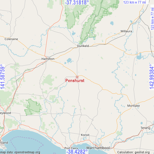
Penshurst GPS coordinates[2]
37° 52' 31.008" South, 142° 17' 26.556" East
| Map corner | latitude | longitude |
|---|---|---|
| Upper-left | -37.31818°, | 141.58759° |
| Center: | -37.87528°, | 142.29071° |
| Lower-right: | -38.4282°, | 142.99384° |
| Map W x H: | 123.4×123.4 km | = 76.7×76.7mi |
| max Lat: | -10.58257° ⇑89.8% North |
| Penshurst: | -37.87528° |
| min Lat: | ⇓10.2% South -43.31423° |
| min Long | Penshurst | max Long |
| 113.53327° | 142.29071° | 153.61246° |
| W 25.5%⇐ | ⇒74.5% E |
Elevation
Elevation of Penshurst is 237 m = 778 ft, and this is 115 m = 377 ft above average elevation for this country.
| Max E: |
1715 m = 5627 ft | 15.7% |
| Penshurst | 237 m 778 ft | |
| Avg. | 122 m = 400 ft | |
Min E: |
-2 m = -7 ft | 84.3% |
See also: Australia elevation on elevation.city.
Geographical zone
Penshurst is located in South temperate zone (between Tropic of Capricorn and the Antarctic Circle). Distance of this Southern Tropic circle is 1605.4 km =997.5 mi to North.| Distance of | km | miles | from Penshurst |
|---|---|---|---|
| Equator | 4211.3 | 2616.8 | to North |
| Tropic Capricorn | 1605.4 | 997.5 | to North |
| Antarctic Circle | 3189.8 | 1982 | to South |
| South Pole | 5795.7 | 3601.3 | to South |


Nearby cities:
15 places around Penshurst: (largest is in red/bold)
• Allansford
62.7 km =39 mi,  154°
154°
• Bolwarra
74.4 km =46.2 mi,  232°
232°
• Bushfield
54.6 km =33.9 mi,  158°
158°
• Coleraine
61.1 km =38 mi,  300°
300°
• Dennington
54.8 km =34.1 mi,  166°
166°
• Dunkeld
25.5 km =15.8 mi,  10°
10°
• Hamilton
27.7 km =17.2 mi, 301°
• Heywood
64.6 km =40.1 mi,  243°
243°
• Koroit
46.8 km =29.1 mi, 171°
• Macarthur
30.9 km =19.2 mi, 235°
• Mortlake
50.8 km =31.6 mi,  116°
116°
• Port Fairy
56.9 km =35.4 mi,  184°
184°
• Terang
68.6 km =42.6 mi,  126°
126°
• Warrnambool
58.9 km =36.6 mi, 162°
• Willaura
53.9 km =33.5 mi,  47°
47°
Sources, notices
• [Note1] Compared only with cities in Australia existing in our database
• [Src1] Map data: © OpenStreetMap contributors (CC-BY-SA)
• [Src2] Other city data from geonames.org with taken over terms of usage.
• [Src3] Geographical zone / Annual Mean Temperature by Robert A. Rohde @ Wikipedia
