Macedon geodata
Macedon (Victoria) is a populated place; located in Australia in Australia/Melbourne (GMT+11) time zone. With population of 1,972 people, there are 2928 cities with bigger population in this country. Compared to other cities in Australia, 82.4% of cities are located further ↑North; 70.1% of cities are located further →East and 93.6% of cities have lower elevation than Macedon. Note1


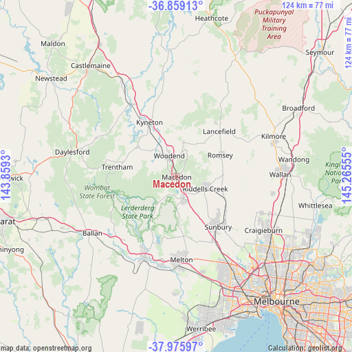
Macedon GPS coordinates[2]
37° 25' 10.668" South, 144° 33' 44.712" East
| Map corner | latitude | longitude |
|---|---|---|
| Upper-left | -36.85913°, | 143.8593° |
| Center: | -37.41963°, | 144.56242° |
| Lower-right: | -37.97597°, | 145.26555° |
| Map W x H: | 124.2×124.2 km | = 77.2×77.2mi |
| max Lat: | -10.58257° ⇑82.4% North |
| Macedon: | -37.41963° |
| min Lat: | ⇓17.6% South -43.31423° |
| min Long | Macedon | max Long |
| 113.53327° | 144.56242° | 153.61246° |
| W 29.9%⇐ | ⇒70.1% E |
Elevation
Elevation of Macedon is 508 m = 1667 ft, and this is 386 m = 1266 ft above average elevation for this country.
| Max E: |
1715 m = 5627 ft | 6.4% |
| Macedon | 508 m 1667 ft | |
| Avg. | 122 m = 400 ft | |
Min E: |
-2 m = -7 ft | 93.6% |
See also: Australia elevation on elevation.city.
Geographical zone
Macedon is located in South temperate zone (between Tropic of Capricorn and the Antarctic Circle). Distance of this Southern Tropic circle is 1554.8 km =966.1 mi to North.| Distance of | km | miles | from Macedon |
|---|---|---|---|
| Equator | 4160.7 | 2585.3 | to North |
| Tropic Capricorn | 1554.8 | 966.1 | to North |
| Antarctic Circle | 3240.5 | 2013.6 | to South |
| South Pole | 5846.4 | 3632.8 | to South |


Nearby cities:
15 places around Macedon: (largest is in red/bold)
• Bullengarook
12.9 km =8 mi,  212°
212°
• Diggers Rest
26.8 km =16.7 mi,  148°
148°
• Gisborne
8.2 km =5.1 mi,  159°
159°
• Gisborne South
14 km =8.7 mi, 164°
• Greendale
28.2 km =17.5 mi,  236°
236°
• Kyneton
21.8 km =13.5 mi,  333°
333°
• Lancefield
22 km =13.7 mi,  44°
44°
• Mount Macedon
2.9 km =1.8 mi, 41°
• New Gisborne
5.6 km =3.5 mi,  144°
144°
• Romsey
17.7 km =11 mi,  64°
64°
• Sunbury
22.7 km =14.1 mi, 140°
• Toolern Vale
20.3 km =12.6 mi,  170°
170°
• Trentham
21.5 km =13.4 mi,  279°
279°
• Tylden
17.3 km =10.7 mi,  307°
307°
• Woodend
7.8 km =4.8 mi,  337°
337°
Sources, notices
• [Note1] Compared only with cities in Australia existing in our database
• [Src1] Map data: © OpenStreetMap contributors (CC-BY-SA)
• [Src2] Other city data from geonames.org with taken over terms of usage.
• [Src3] Geographical zone / Annual Mean Temperature by Robert A. Rohde @ Wikipedia
