Crookwell geodata
Crookwell (New South Wales) is a populated place; located in Australia in Australia/Sydney (GMT+11) time zone. With population of 2,577 people, there are 2515 cities with bigger population in this country. Compared to other cities in Australia, 63% of cities are located further ↑North; 56.1% of cities are located further ←West and 99.3% of cities have lower elevation than Crookwell. Note1


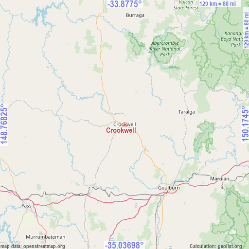
Crookwell GPS coordinates[2]
34° 27' 33.3" South, 149° 28' 16.932" East
| Map corner | latitude | longitude |
|---|---|---|
| Upper-left | -33.8775°, | 148.76825° |
| Center: | -34.45925°, | 149.47137° |
| Lower-right: | -35.03698°, | 150.1745° |
| Map W x H: | 128.9×128.9 km | = 80.1×80.1mi |
| max Lat: | -10.58257° ⇑63% North |
| Crookwell: | -34.45925° |
| min Lat: | ⇓37% South -43.31423° |
| min Long | Crookwell | max Long |
| 113.53327° | 149.47137° | 153.61246° |
| W 56.1%⇐ | ⇒43.9% E |
Elevation
Elevation of Crookwell is 896 m = 2940 ft, and this is 774 m = 2539 ft above average elevation for this country.
| Max E: |
1715 m = 5627 ft | 0.7% |
| Crookwell | 896 m 2940 ft | |
| Avg. | 122 m = 400 ft | |
Min E: |
-2 m = -7 ft | 99.3% |
See also: Australia elevation on elevation.city.
Geographical zone
Crookwell is located in South temperate zone (between Tropic of Capricorn and the Antarctic Circle). Distance of this Southern Tropic circle is 1225.6 km =761.6 mi to North.| Distance of | km | miles | from Crookwell |
|---|---|---|---|
| Equator | 3831.5 | 2380.8 | to North |
| Tropic Capricorn | 1225.6 | 761.6 | to North |
| Antarctic Circle | 3569.7 | 2218.1 | to South |
| South Pole | 6175.6 | 3837.3 | to South |


Nearby cities:
15 places around Crookwell: (largest is in red/bold)
• Berrima
79.6 km =49.5 mi,  92°
92°
• Boorowa
69.3 km =43.1 mi,  272°
272°
• Bowning
68.4 km =42.5 mi,  242°
242°
• Bundanoon
78.7 km =48.9 mi,  106°
106°
• Bywong
79.5 km =49.4 mi,  189°
189°
• Exeter
79.7 km =49.5 mi,  102°
102°
• Goulburn
39.7 km =24.7 mi,  144°
144°
• Gundaroo
67 km =41.6 mi,  197°
197°
• Gunning
40.5 km =25.2 mi,  207°
207°
• Marulan
56.5 km =35.1 mi,  119°
119°
• Murrumbateman
69.8 km =43.4 mi,  215°
215°
• New Berrima
79.3 km =49.3 mi, 93°
• Tallong
62.9 km =39.1 mi, 117°
• Wingello
68.1 km =42.3 mi, 112°
• Yass
66.6 km =41.4 mi,  230°
230°
Sources, notices
• [Note1] Compared only with cities in Australia existing in our database
• [Src1] Map data: © OpenStreetMap contributors (CC-BY-SA)
• [Src2] Other city data from geonames.org with taken over terms of usage.
• [Src3] Geographical zone / Annual Mean Temperature by Robert A. Rohde @ Wikipedia
