Bluff geodata
Bluff (Queensland) is a populated place; located in Australia in Australia/Brisbane (GMT+10) time zone. With population of 535 people, there are 4765 cities with bigger population in this country. Compared to other cities in Australia, 91.4% of cities are located further ↓South; 53.4% of cities are located further ←West and 79.4% of cities have lower elevation than Bluff. Note1


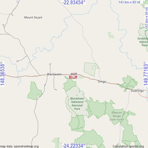
Bluff GPS coordinates[2]
23° 34' 49.872" South, 149° 4' 6.6" East
| Map corner | latitude | longitude |
|---|---|---|
| Upper-left | -22.93454°, | 148.36538° |
| Center: | -23.58052°, | 149.0685° |
| Lower-right: | -24.22334°, | 149.77163° |
| Map W x H: | 143.3×143.3 km | = 89×89mi |
| max Lat: | -10.58257° ⇑8.6% North |
| Bluff: | -23.58052° |
| min Lat: | ⇓91.4% South -43.31423° |
| min Long | Bluff | max Long |
| 113.53327° | 149.0685° | 153.61246° |
| W 53.4%⇐ | ⇒46.6% E |
Elevation
Elevation of Bluff is 173 m = 568 ft, and this is 51 m = 167 ft above average elevation for this country.
| Max E: |
1715 m = 5627 ft | 20.6% |
| Bluff | 173 m 568 ft | |
| Avg. | 122 m = 400 ft | |
Min E: |
-2 m = -7 ft | 79.4% |
See also: Australia elevation on elevation.city.
Geographical zone
Bluff is located in South temperate zone (between Tropic of Capricorn and the Antarctic Circle). Distance of this Southern Tropic circle is 16 km =9.9 mi to North.| Distance of | km | miles | from Bluff |
|---|---|---|---|
| Equator | 2621.9 | 1629.2 | to North |
| Tropic Capricorn | 16 | 9.9 | to North |
| Antarctic Circle | 4779.3 | 2969.7 | to South |
| South Pole | 7385.2 | 4588.9 | to South |


Nearby cities:
15 places around Bluff: (largest is in red/bold)
• Alton Downs
134.4 km =83.5 mi,  76°
76°
• Blackwater
19.3 km =12 mi,  269°
269°
• Capella
120.2 km =74.7 mi,  297°
297°
• Comet
52.9 km =32.9 mi, 267°
• Dysart
132.6 km =82.4 mi,  326°
326°
• Emerald
93 km =57.8 mi, 273°
• Gracemere
142.5 km =88.5 mi, 83°
• Middlemount
93.4 km =58 mi,  336°
336°
• Mount Morgan
134.7 km =83.7 mi,  93°
93°
• Rubyvale
140.8 km =87.5 mi,  277°
277°
• Sapphire
137.7 km =85.6 mi, 275°
• Springsure
116 km =72.1 mi,  239°
239°
• The Gemfields
129.7 km =80.6 mi, 272°
• Tieri
95.4 km =59.3 mi,  309°
309°
• Woorabinda
72.8 km =45.2 mi,  147°
147°
Sources, notices
• [Note1] Compared only with cities in Australia existing in our database
• [Src1] Map data: © OpenStreetMap contributors (CC-BY-SA)
• [Src2] Other city data from geonames.org with taken over terms of usage.
• [Src3] Geographical zone / Annual Mean Temperature by Robert A. Rohde @ Wikipedia
