Comet geodata
Comet (Queensland) is a populated place; located in Australia in Australia/Brisbane (GMT+10) time zone. With population of 680 people, there are 4361 cities with bigger population in this country. Compared to other cities in Australia, 91.4% of cities are located further ↓South; 51.7% of cities are located further ←West and 78.9% of cities have lower elevation than Comet. Note1


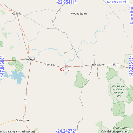
Comet GPS coordinates[2]
23° 36' 0" South, 148° 33' 0" East
| Map corner | latitude | longitude |
|---|---|---|
| Upper-left | -22.95411°, | 147.84688° |
| Center: | -23.6°, | 148.55° |
| Lower-right: | -24.24272°, | 149.25313° |
| Map W x H: | 143.3×143.3 km | = 89×89mi |
| max Lat: | -10.58257° ⇑8.6% North |
| Comet: | -23.6° |
| min Lat: | ⇓91.4% South -43.31423° |
| min Long | Comet | max Long |
| 113.53327° | 148.55° | 153.61246° |
| W 51.7%⇐ | ⇒48.3% E |
Elevation
Elevation of Comet is 167 m = 548 ft, and this is 45 m = 148 ft above average elevation for this country.
| Max E: |
1715 m = 5627 ft | 21.1% |
| Comet | 167 m 548 ft | |
| Avg. | 122 m = 400 ft | |
Min E: |
-2 m = -7 ft | 78.9% |
See also: Australia elevation on elevation.city.
Geographical zone
Comet is located in South temperate zone (between Tropic of Capricorn and the Antarctic Circle). Distance of this Southern Tropic circle is 18.2 km =11.3 mi to North.| Distance of | km | miles | from Comet |
|---|---|---|---|
| Equator | 2624.1 | 1630.5 | to North |
| Tropic Capricorn | 18.2 | 11.3 | to North |
| Antarctic Circle | 4777.1 | 2968.4 | to South |
| South Pole | 7383 | 4587.6 | to South |


Nearby cities:
15 places around Comet: (largest is in red/bold)
• Blackwater
33.6 km =20.9 mi,  86°
86°
• Bluff
52.9 km =32.9 mi, 87°
• Capella
78.6 km =48.8 mi,  316°
316°
• Clermont
127.1 km =79 mi,  312°
312°
• Dysart
114.4 km =71.1 mi,  349°
349°
• Emerald
40.9 km =25.4 mi,  282°
282°
• Middlemount
88.9 km =55.2 mi,  9°
9°
• Moranbah
185.1 km =115 mi,  343°
343°
• Moura
180 km =111.8 mi,  126°
126°
• Rubyvale
89.1 km =55.4 mi, 283°
• Sapphire
85.7 km =53.3 mi, 280°
• Springsure
74 km =46 mi,  219°
219°
• The Gemfields
77.2 km =48 mi, 275°
• Tieri
65.9 km =40.9 mi, 341°
• Woorabinda
109.4 km =68 mi,  122°
122°
Sources, notices
• [Note1] Compared only with cities in Australia existing in our database
• [Src1] Map data: © OpenStreetMap contributors (CC-BY-SA)
• [Src2] Other city data from geonames.org with taken over terms of usage.
• [Src3] Geographical zone / Annual Mean Temperature by Robert A. Rohde @ Wikipedia
