Springsure geodata
Springsure (Queensland) is a populated place; located in Australia in Australia/Brisbane (GMT+10) time zone. With population of 1,115 people, there are 3679 cities with bigger population in this country. Compared to other cities in Australia, 90.7% of cities are located further ↓South; 51.1% of cities are located further ←West and 88.6% of cities have lower elevation than Springsure. Note1


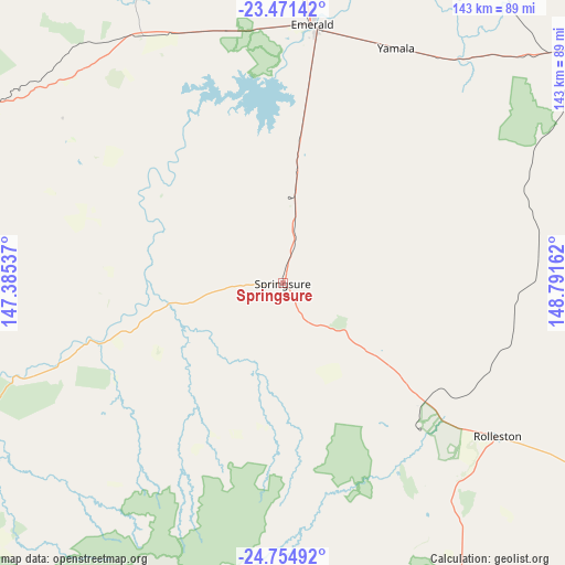
Springsure GPS coordinates[2]
24° 6' 53.208" South, 148° 5' 18.564" East
| Map corner | latitude | longitude |
|---|---|---|
| Upper-left | -23.47142°, | 147.38537° |
| Center: | -24.11478°, | 148.08849° |
| Lower-right: | -24.75492°, | 148.79162° |
| Map W x H: | 142.7×142.7 km | = 88.7×88.7mi |
| max Lat: | -10.58257° ⇑9.3% North |
| Springsure: | -24.11478° |
| min Lat: | ⇓90.7% South -43.31423° |
| min Long | Springsure | max Long |
| 113.53327° | 148.08849° | 153.61246° |
| W 51.1%⇐ | ⇒48.9% E |
Elevation
Elevation of Springsure is 329 m = 1079 ft, and this is 207 m = 679 ft above average elevation for this country.
| Max E: |
1715 m = 5627 ft | 11.4% |
| Springsure | 329 m 1079 ft | |
| Avg. | 122 m = 400 ft | |
Min E: |
-2 m = -7 ft | 88.6% |
See also: Australia elevation on elevation.city.
Geographical zone
Springsure is located in South temperate zone (between Tropic of Capricorn and the Antarctic Circle). Distance of this Southern Tropic circle is 75.4 km =46.9 mi to North.| Distance of | km | miles | from Springsure |
|---|---|---|---|
| Equator | 2681.3 | 1666.1 | to North |
| Tropic Capricorn | 75.4 | 46.9 | to North |
| Antarctic Circle | 4719.9 | 2932.8 | to South |
| South Pole | 7325.7 | 4552 | to South |


Nearby cities:
15 places around Springsure: (largest is in red/bold)
• Blackwater
99.8 km =62 mi,  53°
53°
• Bluff
116 km =72.1 mi,  59°
59°
• Capella
114.6 km =71.2 mi,  356°
356°
• Clermont
150.7 km =93.6 mi,  342°
342°
• Comet
74 km =46 mi,  39°
39°
• Dysart
171.8 km =106.8 mi,  8°
8°
• Emerald
66.2 km =41.1 mi, 6°
• Middlemount
157.7 km =98 mi,  23°
23°
• Moura
197 km =122.4 mi,  104°
104°
• Rubyvale
87 km =54.1 mi,  332°
332°
• Sapphire
82 km =51 mi, 333°
• The Gemfields
71.5 km =44.4 mi, 335°
• Theodore
221.1 km =137.4 mi,  114°
114°
• Tieri
122.5 km =76.1 mi, 12°
• Woorabinda
138.8 km =86.2 mi,  90°
90°
Sources, notices
• [Note1] Compared only with cities in Australia existing in our database
• [Src1] Map data: © OpenStreetMap contributors (CC-BY-SA)
• [Src2] Other city data from geonames.org with taken over terms of usage.
• [Src3] Geographical zone / Annual Mean Temperature by Robert A. Rohde @ Wikipedia
