Sapphire geodata
Sapphire (Queensland) is a populated place; located in Australia in Australia/Brisbane (GMT+10) time zone. With population of 550 people, there are 4706 cities with bigger population in this country. Compared to other cities in Australia, 91.5% of cities are located further ↓South; 50.6% of cities are located further ←West and 85.1% of cities have lower elevation than Sapphire. Note1


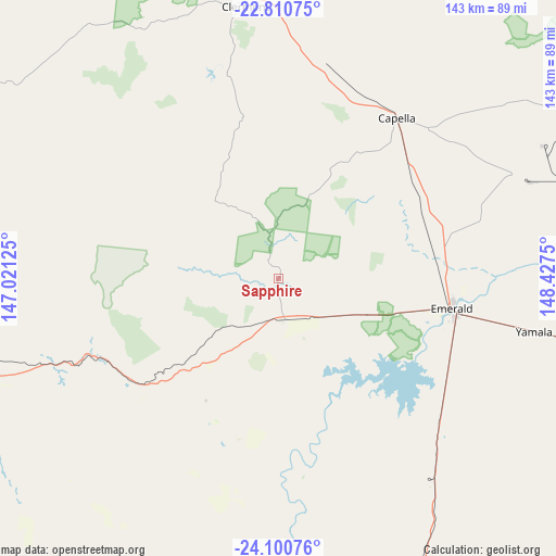
Sapphire GPS coordinates[2]
23° 27' 26.388" South, 147° 43' 27.732" East
| Map corner | latitude | longitude |
|---|---|---|
| Upper-left | -22.81075°, | 147.02125° |
| Center: | -23.45733°, | 147.72437° |
| Lower-right: | -24.10076°, | 148.4275° |
| Map W x H: | 143.4×143.4 km | = 89.1×89.1mi |
| max Lat: | -10.58257° ⇑8.5% North |
| Sapphire: | -23.45733° |
| min Lat: | ⇓91.5% South -43.31423° |
| min Long | Sapphire | max Long |
| 113.53327° | 147.72437° | 153.61246° |
| W 50.6%⇐ | ⇒49.4% E |
Elevation
Elevation of Sapphire is 249 m = 817 ft, and this is 127 m = 417 ft above average elevation for this country.
| Max E: |
1715 m = 5627 ft | 14.9% |
| Sapphire | 249 m 817 ft | |
| Avg. | 122 m = 400 ft | |
Min E: |
-2 m = -7 ft | 85.1% |
See also: Australia elevation on elevation.city.
Geographical zone
Sapphire is located in South temperate zone (between Tropic of Capricorn and the Antarctic Circle). Distance of this Southern Tropic circle is 2.3 km =1.4 mi to North.| Distance of | km | miles | from Sapphire |
|---|---|---|---|
| Equator | 2608.2 | 1620.7 | to North |
| Tropic Capricorn | 2.3 | 1.4 | to North |
| Antarctic Circle | 4793 | 2978.2 | to South |
| South Pole | 7398.9 | 4597.5 | to South |


Nearby cities:
15 places around Sapphire: (largest is in red/bold)
• Blackwater
118.6 km =73.7 mi,  96°
96°
• Bluff
137.7 km =85.6 mi, 95°
• Capella
51.3 km =31.9 mi,  36°
36°
• Clermont
71 km =44.1 mi,  352°
352°
• Comet
85.7 km =53.3 mi, 100°
• Coppabella
178 km =110.6 mi,  19°
19°
• Dysart
115.9 km =72 mi,  33°
33°
• Emerald
44.8 km =27.8 mi, 99°
• Middlemount
122.8 km =76.3 mi,  54°
54°
• Moranbah
165.2 km =102.7 mi,  11°
11°
• Rubyvale
5.1 km =3.2 mi,  329°
329°
• Springsure
82 km =51 mi,  153°
153°
• The Gemfields
11 km =6.8 mi,  137°
137°
• Tieri
78.7 km =48.9 mi, 53°
• Woorabinda
191.5 km =119 mi,  113°
113°
Sources, notices
• [Note1] Compared only with cities in Australia existing in our database
• [Src1] Map data: © OpenStreetMap contributors (CC-BY-SA)
• [Src2] Other city data from geonames.org with taken over terms of usage.
• [Src3] Geographical zone / Annual Mean Temperature by Robert A. Rohde @ Wikipedia
