The Gemfields geodata
The Gemfields (Queensland) is a section of populated place; located in Australia in Australia/Brisbane (GMT+10) time zone. With population of 1,917 people, there are 2960 cities with bigger population in this country. Compared to other cities in Australia, 91.5% of cities are located further ↓South; 50.6% of cities are located further ←West and 83.9% of cities have lower elevation than The Gemfields. Note1


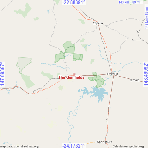
The Gemfields GPS coordinates[2]
23° 31' 48.504" South, 147° 47' 48.444" East
| Map corner | latitude | longitude |
|---|---|---|
| Upper-left | -22.88391°, | 147.09367° |
| Center: | -23.53014°, | 147.79679° |
| Lower-right: | -24.17321°, | 148.49992° |
| Map W x H: | 143.4×143.4 km | = 89.1×89.1mi |
| max Lat: | -10.58257° ⇑8.5% North |
| The Gemfields: | -23.53014° |
| min Lat: | ⇓91.5% South -43.31423° |
| min Long | The Gemfields | max Long |
| 113.53327° | 147.79679° | 153.61246° |
| W 50.6%⇐ | ⇒49.4% E |
Elevation
Elevation of The Gemfields is 229 m = 751 ft, and this is 107 m = 351 ft above average elevation for this country.
| Max E: |
1715 m = 5627 ft | 16.1% |
| The Gemfields | 229 m 751 ft | |
| Avg. | 122 m = 400 ft | |
Min E: |
-2 m = -7 ft | 83.9% |
See also: Australia elevation on elevation.city.
Geographical zone
The Gemfields is located in South temperate zone (between Tropic of Capricorn and the Antarctic Circle). Distance of this Southern Tropic circle is 10.4 km =6.5 mi to North.| Distance of | km | miles | from The Gemfields |
|---|---|---|---|
| Equator | 2616.3 | 1625.7 | to North |
| Tropic Capricorn | 10.4 | 6.5 | to North |
| Antarctic Circle | 4784.9 | 2973.2 | to South |
| South Pole | 7390.8 | 4592.4 | to South |


Nearby cities:
15 places around The Gemfields: (largest is in red/bold)
• Blackwater
110.5 km =68.7 mi,  93°
93°
• Bluff
129.7 km =80.6 mi, 92°
• Capella
54.5 km =33.9 mi,  24°
24°
• Clermont
80.2 km =49.8 mi,  348°
348°
• Comet
77.2 km =48 mi,  95°
95°
• Coppabella
183.4 km =114 mi, 16°
• Dysart
119 km =73.9 mi,  28°
28°
• Emerald
36.8 km =22.9 mi, 88°
• Middlemount
122 km =75.8 mi,  49°
49°
• Moranbah
171.9 km =106.8 mi,  8°
8°
• Rubyvale
15.9 km =9.9 mi,  321°
321°
• Sapphire
11 km =6.8 mi, 317°
• Springsure
71.5 km =44.4 mi,  155°
155°
• Tieri
78.2 km =48.6 mi, 45°
• Woorabinda
181.5 km =112.8 mi,  111°
111°
Sources, notices
• [Note1] Compared only with cities in Australia existing in our database
• [Src1] Map data: © OpenStreetMap contributors (CC-BY-SA)
• [Src2] Other city data from geonames.org with taken over terms of usage.
• [Src3] Geographical zone / Annual Mean Temperature by Robert A. Rohde @ Wikipedia
