Dysart geodata
Dysart (Queensland) is a populated place; located in Australia in Australia/Brisbane (GMT+10) time zone. With population of 4,039 people, there are 1779 cities with bigger population in this country. Compared to other cities in Australia, 92.5% of cities are located further ↓South; 51.5% of cities are located further ←West and 83.4% of cities have lower elevation than Dysart. Note1


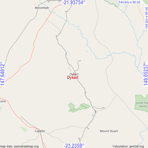
Dysart GPS coordinates[2]
22° 35' 17.7" South, 148° 20' 57.264" East
| Map corner | latitude | longitude |
|---|---|---|
| Upper-left | -21.93754°, | 147.64612° |
| Center: | -22.58825°, | 148.34924° |
| Lower-right: | -23.2359°, | 149.05237° |
| Map W x H: | 144.4×144.4 km | = 89.7×89.7mi |
| max Lat: | -10.58257° ⇑7.5% North |
| Dysart: | -22.58825° |
| min Lat: | ⇓92.5% South -43.31423° |
| min Long | Dysart | max Long |
| 113.53327° | 148.34924° | 153.61246° |
| W 51.5%⇐ | ⇒48.5% E |
Elevation
Elevation of Dysart is 223 m = 732 ft, and this is 101 m = 331 ft above average elevation for this country.
| Max E: |
1715 m = 5627 ft | 16.6% |
| Dysart | 223 m 732 ft | |
| Avg. | 122 m = 400 ft | |
Min E: |
-2 m = -7 ft | 83.4% |
See also: Australia elevation on elevation.city.
Geographical zone
Dysart is located in South Torrid zone (between Equator and Tropic of Capricorn). Distance of this Southern Tropic circle is 94.3 km =58.6 mi to South.| Distance of | km | miles | from Dysart |
|---|---|---|---|
| Equator | 2511.6 | 1560.6 | to North |
| Tropic Capricorn | 94.3 | 58.6 | to South |
| Antarctic Circle | 4889.6 | 3038.3 | to South |
| South Pole | 7495.5 | 4657.5 | to South |


Nearby cities:
15 places around Dysart: (largest is in red/bold)
• Blackwater
123.2 km =76.6 mi,  153°
153°
• Bluff
132.6 km =82.4 mi, 146°
• Capella
64.7 km =40.2 mi,  211°
211°
• Clermont
77.7 km =48.3 mi,  250°
250°
• Comet
114.4 km =71.1 mi,  169°
169°
• Coppabella
71.5 km =44.4 mi,  355°
355°
• Emerald
105.8 km =65.7 mi,  190°
190°
• Hail Creek
113.6 km =70.6 mi,  3°
3°
• Middlemount
43.7 km =27.2 mi,  124°
124°
• Moranbah
72.3 km =44.9 mi,  334°
334°
• Nebo
106.3 km =66.1 mi,  18°
18°
• Rubyvale
113.8 km =70.7 mi,  215°
215°
• Sapphire
115.9 km =72 mi, 213°
• The Gemfields
119 km =73.9 mi, 208°
• Tieri
50 km =31.1 mi,  180°
180°
Sources, notices
• [Note1] Compared only with cities in Australia existing in our database
• [Src1] Map data: © OpenStreetMap contributors (CC-BY-SA)
• [Src2] Other city data from geonames.org with taken over terms of usage.
• [Src3] Geographical zone / Annual Mean Temperature by Robert A. Rohde @ Wikipedia
