Tieri geodata
Tieri (Queensland) is a populated place; located in Australia in Australia/Brisbane (GMT+10) time zone. With population of 1,685 people, there are 3112 cities with bigger population in this country. Compared to other cities in Australia, 92.5% of cities are located further ↓South; 51.5% of cities are located further ←West and 86.1% of cities have lower elevation than Tieri. Note1


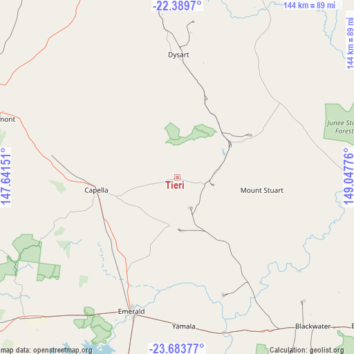
Tieri GPS coordinates[2]
23° 2' 17.844" South, 148° 20' 40.668" East
| Map corner | latitude | longitude |
|---|---|---|
| Upper-left | -22.3897°, | 147.64151° |
| Center: | -23.03829°, | 148.34463° |
| Lower-right: | -23.68377°, | 149.04776° |
| Map W x H: | 143.9×143.9 km | = 89.4×89.4mi |
| max Lat: | -10.58257° ⇑7.5% North |
| Tieri: | -23.03829° |
| min Lat: | ⇓92.5% South -43.31423° |
| min Long | Tieri | max Long |
| 113.53327° | 148.34463° | 153.61246° |
| W 51.5%⇐ | ⇒48.5% E |
Elevation
Elevation of Tieri is 266 m = 873 ft, and this is 144 m = 472 ft above average elevation for this country.
| Max E: |
1715 m = 5627 ft | 13.9% |
| Tieri | 266 m 873 ft | |
| Avg. | 122 m = 400 ft | |
Min E: |
-2 m = -7 ft | 86.1% |
See also: Australia elevation on elevation.city.
Geographical zone
Tieri is located in South Torrid zone (between Equator and Tropic of Capricorn). Distance of this Southern Tropic circle is 44.3 km =27.5 mi to South.| Distance of | km | miles | from Tieri |
|---|---|---|---|
| Equator | 2561.6 | 1591.7 | to North |
| Tropic Capricorn | 44.3 | 27.5 | to South |
| Antarctic Circle | 4839.6 | 3007.2 | to South |
| South Pole | 7445.4 | 4626.4 | to South |


Nearby cities:
15 places around Tieri: (largest is in red/bold)
• Blackwater
81.6 km =50.7 mi,  138°
138°
• Bluff
95.4 km =59.3 mi,  129°
129°
• Capella
33.4 km =20.8 mi,  260°
260°
• Clermont
76.3 km =47.4 mi,  288°
288°
• Comet
65.9 km =40.9 mi,  161°
161°
• Coppabella
121.4 km =75.4 mi,  357°
357°
• Dysart
50 km =31.1 mi,  0°
0°
• Emerald
57.2 km =35.5 mi,  199°
199°
• Middlemount
44.2 km =27.5 mi,  55°
55°
• Moranbah
119.3 km =74.1 mi,  345°
345°
• Nebo
154.6 km =96.1 mi,  13°
13°
• Rubyvale
78.3 km =48.7 mi,  237°
237°
• Sapphire
78.7 km =48.9 mi,  233°
233°
• Springsure
122.5 km =76.1 mi,  192°
192°
• The Gemfields
78.2 km =48.6 mi, 225°
Sources, notices
• [Note1] Compared only with cities in Australia existing in our database
• [Src1] Map data: © OpenStreetMap contributors (CC-BY-SA)
• [Src2] Other city data from geonames.org with taken over terms of usage.
• [Src3] Geographical zone / Annual Mean Temperature by Robert A. Rohde @ Wikipedia
