Lennox Head geodata
Lennox Head (New South Wales) is a populated place; located in Australia in Australia/Sydney (GMT+11) time zone. With population of 6,315 people, there are 1124 cities with bigger population in this country. Compared to other cities in Australia, 73.7% of cities are located further ↓South; 99.9% of cities are located further ←West and 73.6% of cities have higher elevation than Lennox Head. Note1


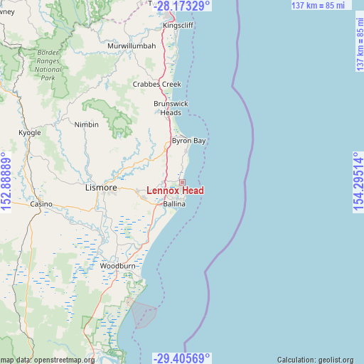
Lennox Head GPS coordinates[2]
28° 47' 28.716" South, 153° 35' 31.236" East
| Map corner | latitude | longitude |
|---|---|---|
| Upper-left | -28.17329°, | 152.88889° |
| Center: | -28.79131°, | 153.59201° |
| Lower-right: | -29.40569°, | 154.29514° |
| Map W x H: | 137×137 km | = 85.1×85.1mi |
| max Lat: | -10.58257° ⇑26.3% North |
| Lennox Head: | -28.79131° |
| min Lat: | ⇓73.7% South -43.31423° |
| min Long | Lennox Head | max Long |
| 113.53327° | 153.59201° | 153.61246° |
| W 99.9%⇐ | ⇒0.099999999999994% E |
Elevation
Elevation of Lennox Head is 20 m = 66 ft, and this is 102 m = 335 ft below average elevation for this country.
| Max E: |
1715 m = 5627 ft | 73.6% |
| Avg. | 122 m = 400 ft | |
| Lennox Head | 20 m = 66 ft | |
Min E: |
-2 m = -7 ft | 26.4% |
See also: Australia elevation on elevation.city.
Geographical zone
Lennox Head is located in South temperate zone (between Tropic of Capricorn and the Antarctic Circle). Distance of this Southern Tropic circle is 595.4 km =370 mi to North.| Distance of | km | miles | from Lennox Head |
|---|---|---|---|
| Equator | 3201.3 | 1989.2 | to North |
| Tropic Capricorn | 595.4 | 370 | to North |
| Antarctic Circle | 4199.9 | 2609.7 | to South |
| South Pole | 6805.8 | 4228.9 | to South |


Nearby cities:
15 places around Lennox Head: (largest is in red/bold)
• Alstonville
15.8 km =9.8 mi,  249°
249°
• Ballina
8.5 km =5.3 mi,  197°
197°
• Bangalow
13.5 km =8.4 mi,  329°
329°
• Byron Bay
15.9 km =9.9 mi,  7°
7°
• Clunes
19.2 km =11.9 mi,  290°
290°
• Cumbalum
7.1 km =4.4 mi,  240°
240°
• East Ballina
7.3 km =4.5 mi,  183°
183°
• Ewingsdale
17.6 km =10.9 mi,  347°
347°
• Federal
21 km =13 mi,  319°
319°
• McLeans Ridges
20.4 km =12.7 mi,  267°
267°
• Skennars Head
4.3 km =2.7 mi,  166°
166°
• Suffolk Park
11.6 km =7.2 mi, 8°
• Tintenbar
6.9 km =4.3 mi,  263°
263°
• West Ballina
9.7 km =6 mi,  216°
216°
• Wollongbar
19.2 km =11.9 mi, 261°
Sources, notices
• [Note1] Compared only with cities in Australia existing in our database
• [Src1] Map data: © OpenStreetMap contributors (CC-BY-SA)
• [Src2] Other city data from geonames.org with taken over terms of usage.
• [Src3] Geographical zone / Annual Mean Temperature by Robert A. Rohde @ Wikipedia
