Mount Buller geodata
Mount Buller (Victoria) is a populated place; located in Australia in Australia/Melbourne (GMT+11) time zone. With population of 2,568 people, there are 2523 cities with bigger population in this country. Compared to other cities in Australia, 81.9% of cities are located further ↑North; 55.4% of cities are located further →East and 100% of cities have lower elevation than Mount Buller. Note1


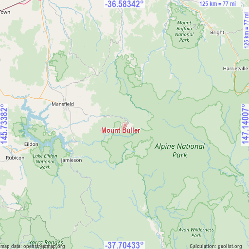
Mount Buller GPS coordinates[2]
37° 8' 45.42" South, 146° 26' 12.984" East
| Map corner | latitude | longitude |
|---|---|---|
| Upper-left | -36.58342°, | 145.73382° |
| Center: | -37.14595°, | 146.43694° |
| Lower-right: | -37.70433°, | 147.14007° |
| Map W x H: | 124.6×124.6 km | = 77.4×77.4mi |
| max Lat: | -10.58257° ⇑81.9% North |
| Mount Buller: | -37.14595° |
| min Lat: | ⇓18.1% South -43.31423° |
| min Long | Mount Buller | max Long |
| 113.53327° | 146.43694° | 153.61246° |
| W 44.6%⇐ | ⇒55.4% E |
Elevation
Elevation of Mount Buller is 1715 m = 5627 ft, and this is 1593 m = 5226 ft above average elevation for this country.
| Max E: |
1715 m = 5627 ft | 0% |
| Mount Buller | 1715 m 5627 ft | |
| Avg. | 122 m = 400 ft | |
Min E: |
-2 m = -7 ft | 100% |
See also: Australia elevation on elevation.city.
Geographical zone
Mount Buller is located in South temperate zone (between Tropic of Capricorn and the Antarctic Circle). Distance of this Southern Tropic circle is 1524.3 km =947.2 mi to North.| Distance of | km | miles | from Mount Buller |
|---|---|---|---|
| Equator | 4130.2 | 2566.4 | to North |
| Tropic Capricorn | 1524.3 | 947.2 | to North |
| Antarctic Circle | 3270.9 | 2032.4 | to South |
| South Pole | 5876.8 | 3651.7 | to South |


Nearby cities:
15 places around Mount Buller: (largest is in red/bold)
• Alexandra
64.5 km =40.1 mi,  265°
265°
• Benalla
77.4 km =48.1 mi,  328°
328°
• Bonnie Doon
52.6 km =32.7 mi,  285°
285°
• Bright
65.6 km =40.8 mi,  45°
45°
• Dinner Plain
72.6 km =45.1 mi,  79°
79°
• Eildon
47.4 km =29.5 mi,  258°
258°
• Glenrowan
78.2 km =48.6 mi,  346°
346°
• Hotham Heights
65.7 km =40.8 mi,  74°
74°
• Mansfield
32.6 km =20.3 mi, 288°
• Merrijig
17.3 km =10.7 mi, 287°
• Milawa
79.2 km =49.2 mi,  359°
359°
• Mount Beauty
79.9 km =49.6 mi,  55°
55°
• Myrtleford
69.9 km =43.4 mi,  21°
21°
• Oxley
77.6 km =48.2 mi, 355°
• Porepunkah
65.4 km =40.6 mi,  40°
40°
Sources, notices
• [Note1] Compared only with cities in Australia existing in our database
• [Src1] Map data: © OpenStreetMap contributors (CC-BY-SA)
• [Src2] Other city data from geonames.org with taken over terms of usage.
• [Src3] Geographical zone / Annual Mean Temperature by Robert A. Rohde @ Wikipedia
