Merrijig geodata
Merrijig (Victoria) is a populated place; located in Australia in Australia/Melbourne (GMT+11) time zone. With population of 735 people, there are 4271 cities with bigger population in this country. Compared to other cities in Australia, 81.8% of cities are located further ↑North; 56.3% of cities are located further →East and 92.6% of cities have lower elevation than Merrijig. Note1


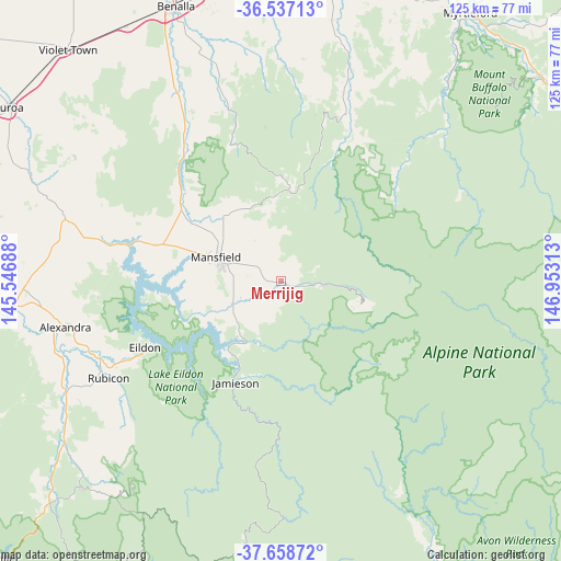
Merrijig GPS coordinates[2]
37° 6' 0" South, 146° 15' 0" East
| Map corner | latitude | longitude |
|---|---|---|
| Upper-left | -36.53713°, | 145.54688° |
| Center: | -37.1°, | 146.25° |
| Lower-right: | -37.65872°, | 146.95313° |
| Map W x H: | 124.7×124.7 km | = 77.5×77.5mi |
| max Lat: | -10.58257° ⇑81.8% North |
| Merrijig: | -37.1° |
| min Lat: | ⇓18.2% South -43.31423° |
| min Long | Merrijig | max Long |
| 113.53327° | 146.25° | 153.61246° |
| W 43.7%⇐ | ⇒56.3% E |
Elevation
Elevation of Merrijig is 458 m = 1503 ft, and this is 336 m = 1102 ft above average elevation for this country.
| Max E: |
1715 m = 5627 ft | 7.4% |
| Merrijig | 458 m 1503 ft | |
| Avg. | 122 m = 400 ft | |
Min E: |
-2 m = -7 ft | 92.6% |
See also: Australia elevation on elevation.city.
Geographical zone
Merrijig is located in South temperate zone (between Tropic of Capricorn and the Antarctic Circle). Distance of this Southern Tropic circle is 1519.2 km =944 mi to North.| Distance of | km | miles | from Merrijig |
|---|---|---|---|
| Equator | 4125.1 | 2563.2 | to North |
| Tropic Capricorn | 1519.2 | 944 | to North |
| Antarctic Circle | 3276 | 2035.6 | to South |
| South Pole | 5881.9 | 3654.8 | to South |


Nearby cities:
15 places around Merrijig: (largest is in red/bold)
• Alexandra
48.8 km =30.3 mi,  257°
257°
• Benalla
65.5 km =40.7 mi,  338°
338°
• Bonnie Doon
35.3 km =21.9 mi,  285°
285°
• Bright
75.3 km =46.8 mi,  56°
56°
• Eildon
33.3 km =20.7 mi,  243°
243°
• Euroa
71.5 km =44.4 mi,  302°
302°
• Glenrowan
70.8 km =44 mi,  358°
358°
• Mansfield
15.3 km =9.5 mi, 290°
• Milawa
75.9 km =47.2 mi,  12°
12°
• Mount Buller
17.3 km =10.7 mi,  107°
107°
• Myrtleford
73.3 km =45.5 mi,  35°
35°
• Oxley
73 km =45.4 mi, 8°
• Porepunkah
73.9 km =45.9 mi,  52°
52°
• Violet Town
70.2 km =43.6 mi,  317°
317°
• Yea
73.9 km =45.9 mi, 260°
Sources, notices
• [Note1] Compared only with cities in Australia existing in our database
• [Src1] Map data: © OpenStreetMap contributors (CC-BY-SA)
• [Src2] Other city data from geonames.org with taken over terms of usage.
• [Src3] Geographical zone / Annual Mean Temperature by Robert A. Rohde @ Wikipedia
